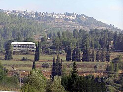
בית ספר אזורי עין כרם
 בית הספר, מעליו בתי היישוב מבשרת ציון בית הספר, מעליו בתי היישוב מבשרת ציון
| |
| מדינה | |
| מחוז | ירושלים |
| מועצה אזורית | מטה יהודה |
| גובה ממוצע[1] | 574 מטר |
| תאריך ייסוד | 1952 |
| סוג יישוב | יישוב מוסדי |
| נתוני אוכלוסייה לפי הלמ"ס לסוף 2023[1] | |
| - אוכלוסייה | 61 תושבים |
| - מתוכם, תושבי ישראל | 61 תושבי ישראל |
<mapframe align="center" height="480" latitude="31.73" longitude="35.05" text="<div style="text-align:center;">מפת היישובים של מועצה אזורית מטה יהודה<br />באדום - בית ספר אזורי עין כרם<br />בירוק - מיקום בניין המועצה</div>" width="560" zoom="11">[{"properties":{"title":"geomask1","marker-color":"#0000FF"},"type":"ExternalData","service":"geomask","ids":"Q799284"},{"features":[{"type":"Feature","geometry":{"coordinates":[35.0676465923132,31.831996523923],"type":"Point"},"properties":{"marker-size":"small","title":"נטף","marker-color":"#0000FF"}},{"type":"Feature","geometry":{"coordinates":[34.9556763879237,31.8311952910857],"type":"Point"},"properties":{"marker-size":"small","title":"נחשון","marker-color":"#0000FF"}},{"type":"Feature","geometry":{"coordinates":[34.925683807344,31.8287882530478],"type":"Point"},"properties":{"marker-size":"small","title":"בקוע","marker-color":"#0000FF"}},{"type":"Feature","geometry":{"coordinates":[34.9785260223232,31.8177104860201],"type":"Point"},"properties":{"marker-size":"small","title":"נווה שלום","marker-color":"#0000FF"}},{"type":"Feature","geometry":{"coordinates":[35.1108655293526,31.8176965390773],"type":"Point"},"properties":{"marker-size":"small","title":"מעלה החמישה","marker-color":"#0000FF"}},{"type":"Feature","geometry":{"coordinates":[35.1055892371023,31.8133637233424],"type":"Point"},"properties":{"marker-size":"small","title":"ידידה","marker-color":"#0000FF"}},{"type":"Feature","geometry":{"coordinates":[35.1042181172241,31.8116491574271],"type":"Point"},"properties":{"marker-size":"small","title":"כפר הנוער קריית יערים","marker-color":"#0000FF"}},{"type":"Feature","geometry":{"coordinates":[35.1197440454182,31.8104880714421],"type":"Point"},"properties":{"marker-size":"small","title":"קריית ענבים","marker-color":"#0000FF"}},{"type":"Feature","geometry":{"coordinates":[35.0896460020013,31.8098331480275],"type":"Point"},"properties":{"marker-size":"small","title":"יד השמונה","marker-color":"#0000FF"}},{"type":"Feature","geometry":{"coordinates":[34.9495047953107,31.8090881446983],"type":"Point"},"properties":{"marker-size":"small","title":"הראל","marker-color":"#0000FF"}},{"type":"Feature","geometry":{"coordinates":[35.081305276587,31.8080216612364],"type":"Point"},"properties":{"marker-size":"small","title":"נווה אילן","marker-color":"#0000FF"}},{"type":"Feature","geometry":{"coordinates":[34.9026278172536,31.8051075720472],"type":"Point"},"properties":{"marker-size":"small","title":"טל שחר","marker-color":"#0000FF"}},{"type":"Feature","geometry":{"coordinates":[34.9389559238356,31.8049181045212],"type":"Point"},"properties":{"marker-size":"small","title":"גיזו","marker-color":"#0000FF"}},{"type":"Feature","geometry":{"coordinates":[34.9312479980794,31.8045410346457],"type":"Point"},"properties":{"marker-size":"small","title":"צלפון","marker-color":"#0000FF"}},{"type":"Feature","geometry":{"coordinates":[35.1259800699809,31.8045399435034],"type":"Point"},"properties":{"marker-size":"small","title":"בית נקופה","marker-color":"#0000FF"}},{"type":"Feature","geometry":{"coordinates":[35.0111939894389,31.8023429777083],"type":"Point"},"properties":{"marker-size":"small","title":"מסילת ציון","marker-color":"#0000FF"}},{"type":"Feature","geometry":{"coordinates":[34.9746594932368,31.8010195980549],"type":"Point"},"properties":{"marker-size":"small","title":"תעוז","marker-color":"#0000FF"}},{"type":"Feature","geometry":{"coordinates":[35.0780447265119,31.7982786031418],"type":"Point"},"properties":{"marker-size":"small","title":"שואבה","marker-color":"#0000FF"}},{"type":"Feature","geometry":{"coordinates":[35.0653748392207,31.7971831610626],"type":"Point"},"properties":{"marker-size":"small","title":"שורש","marker-color":"#0000FF"}},{"type":"Feature","geometry":{"coordinates":[35.0367642537881,31.7940823776834],"type":"Point"},"properties":{"marker-size":"small","title":"בית מאיר","marker-color":"#0000FF"}},{"type":"Feature","geometry":{"coordinates":[35.1576664639112,31.7938236757914],"type":"Point"},"properties":{"marker-size":"small","title":"מוצא עילית","marker-color":"#0000FF"}},{"type":"Feature","geometry":{"coordinates":[34.9465916293051,31.7933001429528],"type":"Point"},"properties":{"marker-size":"small","title":"כפר אוריה","marker-color":"#0000FF"}},{"type":"Feature","geometry":{"coordinates":[35.1198653605666,31.7932630230601],"type":"Point"},"properties":{"marker-size":"small","title":"עין נקובא","marker-color":"#0000FF"}},{"type":"Feature","geometry":{"coordinates":[35.115011071178,31.7902836244628],"type":"Point"},"properties":{"marker-size":"small","title":"עין ראפה","marker-color":"#0000FF"}},{"type":"Feature","geometry":{"coordinates":[35.091997161122,31.7869285307505],"type":"Point"},"properties":{"marker-size":"small","title":"גבעת יערים","marker-color":"#0000FF"}},{"type":"Feature","geometry":{"coordinates":[35.1194519177937,31.7835228628547],"type":"Point"},"properties":{"marker-size":"small","title":"צובה","marker-color":"#0000FF"}},{"type":"Feature","geometry":{"coordinates":[34.9817778473593,31.782995509285],"type":"Point"},"properties":{"marker-size":"small","title":"תרום","marker-color":"#0000FF"}},{"type":"Feature","geometry":{"coordinates":[35.1617899091645,31.7821011884514],"type":"Point"},"properties":{"marker-size":"small","title":"בית זית","marker-color":"#0000FF"}},{"type":"Feature","geometry":{"coordinates":[35.009126569642,31.7811466064154],"type":"Point"},"properties":{"marker-size":"small","title":"אשתאול","marker-color":"#0000FF"}},{"type":"Feature","geometry":{"coordinates":[35.095279567314,31.7789951866804],"type":"Point"},"properties":{"marker-size":"small","title":"בית חולים איתנים","marker-color":"#0000FF"}},{"type":"Feature","geometry":{"coordinates":[35.1530291025659,31.7782200200254],"type":"Point"},"properties":{"marker-size":"small","title":"בית ספר אזורי עין כרם","marker-color":"#FF0000"}},{"type":"Feature","geometry":{"coordinates":[34.9471660414334,31.7765271205505],"type":"Point"},"properties":{"marker-size":"small","title":"דיר ראפאת","marker-color":"#0000FF"}},{"type":"Feature","geometry":{"coordinates":[34.9517099853645,31.7749129230047],"type":"Point"},"properties":{"marker-size":"small","title":"גבעת שמש","marker-color":"#0000FF"}},{"type":"Feature","geometry":{"coordinates":[35.0493630192319,31.7740775125737],"type":"Point"},"properties":{"marker-size":"small","title":"כסלון","marker-color":"#0000FF"}},{"type":"Feature","geometry":{"coordinates":[35.0732218553574,31.7738338269269],"type":"Point"},"properties":{"marker-size":"small","title":"רמת רזיאל","marker-color":"#0000FF"}},{"type":"Feature","geometry":{"coordinates":[35.0034572593471,31.7664377588314],"type":"Point"},"properties":{"marker-size":"small","title":"נחם","marker-color":"#0000FF"}},{"type":"Feature","geometry":{"coordinates":[34.999254,31.764413],"type":"Point"},"properties":{"marker-size":"small","title":"בניין מועצה אזורית מטה יהודה","marker-color":"#00FF00"}},{"type":"Feature","geometry":{"coordinates":[34.9691591871385,31.7629519256861],"type":"Point"},"properties":{"marker-size":"small","title":"צרעה","marker-color":"#0000FF"}},{"type":"Feature","geometry":{"coordinates":[35.134670861365,31.7628799178354],"type":"Point"},"properties":{"marker-size":"small","title":"אבן ספיר","marker-color":"#0000FF"}},{"type":"Feature","geometry":{"coordinates":[35.1529369884034,31.7539603633985],"type":"Point"},"properties":{"marker-size":"small","title":"אורה","marker-color":"#0000FF"}},{"type":"Feature","geometry":{"coordinates":[35.1416451719615,31.7516104839557],"type":"Point"},"properties":{"marker-size":"small","title":"עמינדב","marker-color":"#0000FF"}},{"type":"Feature","geometry":{"coordinates":[34.9655995012156,31.7515820750631],"type":"Point"},"properties":{"marker-size":"small","title":"ישעי","marker-color":"#0000FF"}},{"type":"Feature","geometry":{"coordinates":[34.8860231397608,31.7507764795177],"type":"Point"},"properties":{"marker-size":"small","title":"תירוש","marker-color":"#0000FF"}},{"type":"Feature","geometry":{"coordinates":[35.0072967920365,31.7478657914362],"type":"Point"},"properties":{"marker-size":"small","title":"מחסיה","marker-color":"#0000FF"}},{"type":"Feature","geometry":{"coordinates":[35.0583816793908,31.7452291757573],"type":"Point"},"properties":{"marker-size":"small","title":"נס הרים","marker-color":"#0000FF"}},{"type":"Feature","geometry":{"coordinates":[34.8785648255164,31.7407471563755],"type":"Point"},"properties":{"marker-size":"small","title":"גפן","marker-color":"#0000FF"}},{"type":"Feature","geometry":{"coordinates":[35.2183733116408,31.7398110594845],"type":"Point"},"properties":{"marker-size":"small","title":"רמת רחל","marker-color":"#0000FF"}},{"type":"Feature","geometry":{"coordinates":[34.9992041653401,31.7325216125401],"type":"Point"},"properties":{"marker-size":"small","title":"זנוח","marker-color":"#0000FF"}},{"type":"Feature","geometry":{"coordinates":[35.0724398041795,31.7298229476091],"type":"Point"},"properties":{"marker-size":"small","title":"בר גיורא","marker-color":"#0000FF"}},{"type":"Feature","geometry":{"coordinates":[35.1058976031625,31.721826803964],"type":"Point"},"properties":{"marker-size":"small","title":"מבוא ביתר","marker-color":"#0000FF"}},{"type":"Feature","geometry":{"coordinates":[34.9205199814769,31.721187485243],"type":"Point"},"properties":{"marker-size":"small","title":"שדות מיכה","marker-color":"#0000FF"}},{"type":"Feature","geometry":{"coordinates":[35.0621170868133,31.7179975896608],"type":"Point"},"properties":{"marker-size":"small","title":"מטע","marker-color":"#0000FF"}},{"type":"Feature","geometry":{"coordinates":[34.9449243908007,31.7096959376404],"type":"Point"},"properties":{"marker-size":"small","title":"זכריה","marker-color":"#0000FF"}},{"type":"Feature","geometry":{"coordinates":[34.9122584470188,31.6977207528911],"type":"Point"},"properties":{"marker-size":"small","title":"עגור","marker-color":"#0000FF"}},{"type":"Feature","geometry":{"coordinates":[34.9825322978636,31.6880324423825],"type":"Point"},"properties":{"marker-size":"small","title":"נתיב הל\"ה","marker-color":"#0000FF"}},{"type":"Feature","geometry":{"coordinates":[34.8866650863877,31.6863863375325],"type":"Point"},"properties":{"marker-size":"small","title":"לוזית","marker-color":"#0000FF"}},{"type":"Feature","geometry":{"coordinates":[35.0168229259067,31.6817746073788],"type":"Point"},"properties":{"marker-size":"small","title":"אביעזר","marker-color":"#0000FF"}},{"type":"Feature","geometry":{"coordinates":[34.9349954840145,31.6774792451615],"type":"Point"},"properties":{"marker-size":"small","title":"שריגים (לי-און)","marker-color":"#0000FF"}},{"type":"Feature","geometry":{"coordinates":[35.0054517252359,31.6729191684556],"type":"Point"},"properties":{"marker-size":"small","title":"נווה מיכאל","marker-color":"#0000FF"}},{"type":"Feature","geometry":{"coordinates":[34.9454533662219,31.6711879649143],"type":"Point"},"properties":{"marker-size":"small","title":"גבעת ישעיהו","marker-color":"#0000FF"}},{"type":"Feature","geometry":{"coordinates":[34.9949341264531,31.6605468734791],"type":"Point"},"properties":{"marker-size":"small","title":"אדרת","marker-color":"#0000FF"}},{"type":"Feature","geometry":{"coordinates":[34.9439025715337,31.6600919889999],"type":"Point"},"properties":{"marker-size":"small","title":"צפרירים","marker-color":"#0000FF"}},{"type":"Feature","geometry":{"coordinates":[34.9542101055324,31.6302611523296],"type":"Point"},"properties":{"marker-size":"small","title":"נחושה","marker-color":"#0000FF"}},{"type":"Feature","geometry":{"coordinates":[34.9249340070787,31.6213620945592],"type":"Point"},"properties":{"marker-size":"small","title":"כפר זוהרים","marker-color":"#0000FF"}}],"type":"FeatureCollection"}]</mapframe>
| |
| מדד חברתי-כלכלי - אשכול לשנת 2021[2] |
3 מתוך 10 |
| https://einkerem.org.il | |
בית הספר האזורי חקלאי עֵין כֶּרֶם (שם קודם: בית הספר החקלאי עין כרם) הוא בית ספר תיכון חקלאי קהילתי אזורי מקיף של המועצה האזורית מטה יהודה הממוקם מערבית לשכונת עין כרם וסמוך לבית זית.
בסמוך לבית הספר ממוקם בית הספר היסודי "עין הרים", בו לומדים תלמידים בכיתות א'-ו'.
היסטוריה
בית הספר החקלאי נחנך באוקטובר 1952 במשכנו הזמני במבנים ששימשו את חוות הלימוד, שהוקמה על ידי רחל ינאית בן-צבי, שהועברה לעין כרם מהשטח המפורז ממזרח לתלפיות, לאחר מלחמת העצמאות. בין מקימי המקום היה גם ד"ר נסים משיח[3]. כפנימיות שימשו בתים שננטשו על ידי בעליהם הערבים במלחמת העצמאות[4]. בסוף 1955, בעקבות נטישת חברי נווה אילן את קיבוצם, ביקש משרד החקלאות להעביר את בית הספר לנווה אילן[5], אולם העובדים סירבו[6] ומשרד החקלאות הקים לבית הספר קמפוס בקרבת בעין כרם. בשנת 1957 סבל בית הספר ממיעוט תלמידים[7]. בסביבות שנת 1960 הועבר בית הספר מאחריות משרד החקלאות למשרד החינוך[8]. בשנת 2002 הועברה פנימיית כרמית לכפר ושמה הועבר לעין כרמית.
אופי בית הספר
בית הספר האזורי-חקלאי עין כרם הוא בית ספר על-יסודי באזור ההר של המועצה האזורית מטה יהודה, ונמצא בבעלות של משרד החינוך, תחת המינהל לחינוך התיישבותי.
בית הספר הוקם בשנת 1952 במבנים אשר שימשו את חוות הלימוד שייסדה רחל ינאית בן-צבי, בשכונת עין כרם שבירושלים, ובתקופה זו קיבל את שמו. בשנת 1960 עבר בית הספר אל משכנו הנוכחי מחוץ לעיר, והפך לכפר נוער חקלאי.
בית הספר הוא חלק ממארג חינוכי המכונה "כפר נוער" אשר מורכב משלושה גופים חינוכיים: בית ספר אזורי, פנימייה ומשק חקלאי. מרבית התלמידים משלבים לימודי חקלאות בין שלל מקצועות הלימוד, ואף ניגשים לבגרות של 5 יח"ל במקצוע מדעי זה.
תלמידיו מגיעים ממגוון יישובים: מושבים, קיבוצים שיתופיים ומתחדשים והרחבות יישוביות, והוא מוזן על ידי שני בתי ספר יסודיים: "אלון" ו"עין הרים". בנוסף ליסודיים מזינה את בית הספר גם פנימיית עין כרמית אשר סמוכה לבית הספר, שאליה מגיעים חניכים מכל רחבי הארץ.
קישורים חיצוניים
- "בית ספר אזורי עין כרם", באתר הכל אודות מוסדות החינוך
- אתר הרשמי של בית הספר האזורי חקלאי עין כרם
 נחנך בית ספר חקלאי חדש בעין כרם, ירושלים, 1960, באתר ארכיון הסרטים הישראלי בסינמטק ירושלים
הערות שוליים
- ^ 1 2 אוכלוסייה בעיריות, במועצות המקומיות והאזוריות וביישובים בעלי 2,000 תושבים לפחות - לפי טבלה חודשית של למ"ס עבור סוף דצמבר 2024 (אומדן), בכל יתר היישובים - לפי טבלה שנתית של למ"ס עבור סוף 2023.
- ^ הנתונים לפי טבלת מדד חברתי כלכלי של למ"ס נכון לשנת 2021
- ^ בי"ס חקלאי תיכוני נחנך בעין כרם, הצופה, 30 באוקטובר 1952
- ^ אמנון שלף, בית הספר החקלאי בעין כרם, זמנים, 20 ביולי 1954
- ^ בי"ס לחקלאות הררית יוקם בנוה אילן, למרחב, 20 בדצמבר 1955
- ^ אהרן דולב, העקרון ניצח - הקיבוץ ננטש, מעריב, 10 בפברואר 1956
- ^ סכנת סגירת ביה"ס החקלאי בעין כרם, הַבֹּקֶר, 15 במאי 1957
- ^ תנחום לוין, החינוך בפרוזדור ירושלים, הצופה, 27 בדצמבר 1964
| ||||||||||||||||


