תרום
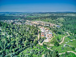
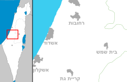
תָּרוּם הוא מושב עובדים של ארגון המושבים של הפועל המזרחי, הממוקם צפונית לבית שמש ושייך למועצה האזורית מטה יהודה.
 | |
| מדינה | |
| מחוז | ירושלים |
| מועצה אזורית | מטה יהודה |
| גובה ממוצע[1] | 287 מטר |
| תאריך ייסוד | 1950 |
| תנועה מיישבת | הפועל המזרחי |
| סוג יישוב | מושב |
| נתוני אוכלוסייה לפי הלמ"ס לסוף 2023[1] | |
| - אוכלוסייה | 930 תושבים |
| - מתוכם, תושבי ישראל | 916 תושבי ישראל |
<mapframe align="center" height="480" latitude="31.73" longitude="35.05" text="<div style="text-align:center;">מפת היישובים של מועצה אזורית מטה יהודה<br />באדום - תרום<br />בירוק - מיקום בניין המועצה</div>" width="560" zoom="11">[{"properties":{"title":"geomask1","marker-color":"#0000FF"},"type":"ExternalData","service":"geomask","ids":"Q799284"},{"features":[{"type":"Feature","geometry":{"coordinates":[35.0676465923132,31.831996523923],"type":"Point"},"properties":{"marker-size":"small","title":"נטף","marker-color":"#0000FF"}},{"type":"Feature","geometry":{"coordinates":[34.9556763879237,31.8311952910857],"type":"Point"},"properties":{"marker-size":"small","title":"נחשון","marker-color":"#0000FF"}},{"type":"Feature","geometry":{"coordinates":[34.925683807344,31.8287882530478],"type":"Point"},"properties":{"marker-size":"small","title":"בקוע","marker-color":"#0000FF"}},{"type":"Feature","geometry":{"coordinates":[34.9785260223232,31.8177104860201],"type":"Point"},"properties":{"marker-size":"small","title":"נווה שלום","marker-color":"#0000FF"}},{"type":"Feature","geometry":{"coordinates":[35.1108655293526,31.8176965390773],"type":"Point"},"properties":{"marker-size":"small","title":"מעלה החמישה","marker-color":"#0000FF"}},{"type":"Feature","geometry":{"coordinates":[35.1055892371023,31.8133637233424],"type":"Point"},"properties":{"marker-size":"small","title":"ידידה","marker-color":"#0000FF"}},{"type":"Feature","geometry":{"coordinates":[35.1042181172241,31.8116491574271],"type":"Point"},"properties":{"marker-size":"small","title":"כפר הנוער קריית יערים","marker-color":"#0000FF"}},{"type":"Feature","geometry":{"coordinates":[35.1197440454182,31.8104880714421],"type":"Point"},"properties":{"marker-size":"small","title":"קריית ענבים","marker-color":"#0000FF"}},{"type":"Feature","geometry":{"coordinates":[35.0896460020013,31.8098331480275],"type":"Point"},"properties":{"marker-size":"small","title":"יד השמונה","marker-color":"#0000FF"}},{"type":"Feature","geometry":{"coordinates":[34.9495047953107,31.8090881446983],"type":"Point"},"properties":{"marker-size":"small","title":"הראל","marker-color":"#0000FF"}},{"type":"Feature","geometry":{"coordinates":[35.081305276587,31.8080216612364],"type":"Point"},"properties":{"marker-size":"small","title":"נווה אילן","marker-color":"#0000FF"}},{"type":"Feature","geometry":{"coordinates":[34.9026278172536,31.8051075720472],"type":"Point"},"properties":{"marker-size":"small","title":"טל שחר","marker-color":"#0000FF"}},{"type":"Feature","geometry":{"coordinates":[34.9389559238356,31.8049181045212],"type":"Point"},"properties":{"marker-size":"small","title":"גיזו","marker-color":"#0000FF"}},{"type":"Feature","geometry":{"coordinates":[34.9312479980794,31.8045410346457],"type":"Point"},"properties":{"marker-size":"small","title":"צלפון","marker-color":"#0000FF"}},{"type":"Feature","geometry":{"coordinates":[35.1259800699809,31.8045399435034],"type":"Point"},"properties":{"marker-size":"small","title":"בית נקופה","marker-color":"#0000FF"}},{"type":"Feature","geometry":{"coordinates":[35.0111939894389,31.8023429777083],"type":"Point"},"properties":{"marker-size":"small","title":"מסילת ציון","marker-color":"#0000FF"}},{"type":"Feature","geometry":{"coordinates":[34.9746594932368,31.8010195980549],"type":"Point"},"properties":{"marker-size":"small","title":"תעוז","marker-color":"#0000FF"}},{"type":"Feature","geometry":{"coordinates":[35.0780447265119,31.7982786031418],"type":"Point"},"properties":{"marker-size":"small","title":"שואבה","marker-color":"#0000FF"}},{"type":"Feature","geometry":{"coordinates":[35.0653748392207,31.7971831610626],"type":"Point"},"properties":{"marker-size":"small","title":"שורש","marker-color":"#0000FF"}},{"type":"Feature","geometry":{"coordinates":[35.0367642537881,31.7940823776834],"type":"Point"},"properties":{"marker-size":"small","title":"בית מאיר","marker-color":"#0000FF"}},{"type":"Feature","geometry":{"coordinates":[35.1576664639112,31.7938236757914],"type":"Point"},"properties":{"marker-size":"small","title":"מוצא עילית","marker-color":"#0000FF"}},{"type":"Feature","geometry":{"coordinates":[34.9465916293051,31.7933001429528],"type":"Point"},"properties":{"marker-size":"small","title":"כפר אוריה","marker-color":"#0000FF"}},{"type":"Feature","geometry":{"coordinates":[35.1198653605666,31.7932630230601],"type":"Point"},"properties":{"marker-size":"small","title":"עין נקובא","marker-color":"#0000FF"}},{"type":"Feature","geometry":{"coordinates":[35.115011071178,31.7902836244628],"type":"Point"},"properties":{"marker-size":"small","title":"עין ראפה","marker-color":"#0000FF"}},{"type":"Feature","geometry":{"coordinates":[35.091997161122,31.7869285307505],"type":"Point"},"properties":{"marker-size":"small","title":"גבעת יערים","marker-color":"#0000FF"}},{"type":"Feature","geometry":{"coordinates":[35.1194519177937,31.7835228628547],"type":"Point"},"properties":{"marker-size":"small","title":"צובה","marker-color":"#0000FF"}},{"type":"Feature","geometry":{"coordinates":[34.9817778473593,31.782995509285],"type":"Point"},"properties":{"marker-size":"small","title":"תרום","marker-color":"#FF0000"}},{"type":"Feature","geometry":{"coordinates":[35.1617899091645,31.7821011884514],"type":"Point"},"properties":{"marker-size":"small","title":"בית זית","marker-color":"#0000FF"}},{"type":"Feature","geometry":{"coordinates":[35.009126569642,31.7811466064154],"type":"Point"},"properties":{"marker-size":"small","title":"אשתאול","marker-color":"#0000FF"}},{"type":"Feature","geometry":{"coordinates":[35.095279567314,31.7789951866804],"type":"Point"},"properties":{"marker-size":"small","title":"בית חולים איתנים","marker-color":"#0000FF"}},{"type":"Feature","geometry":{"coordinates":[35.1530291025659,31.7782200200254],"type":"Point"},"properties":{"marker-size":"small","title":"בית ספר אזורי עין כרם","marker-color":"#0000FF"}},{"type":"Feature","geometry":{"coordinates":[34.9471660414334,31.7765271205505],"type":"Point"},"properties":{"marker-size":"small","title":"דיר ראפאת","marker-color":"#0000FF"}},{"type":"Feature","geometry":{"coordinates":[34.9517099853645,31.7749129230047],"type":"Point"},"properties":{"marker-size":"small","title":"גבעת שמש","marker-color":"#0000FF"}},{"type":"Feature","geometry":{"coordinates":[35.0493630192319,31.7740775125737],"type":"Point"},"properties":{"marker-size":"small","title":"כסלון","marker-color":"#0000FF"}},{"type":"Feature","geometry":{"coordinates":[35.0732218553574,31.7738338269269],"type":"Point"},"properties":{"marker-size":"small","title":"רמת רזיאל","marker-color":"#0000FF"}},{"type":"Feature","geometry":{"coordinates":[35.0034572593471,31.7664377588314],"type":"Point"},"properties":{"marker-size":"small","title":"נחם","marker-color":"#0000FF"}},{"type":"Feature","geometry":{"coordinates":[34.999254,31.764413],"type":"Point"},"properties":{"marker-size":"small","title":"בניין מועצה אזורית מטה יהודה","marker-color":"#00FF00"}},{"type":"Feature","geometry":{"coordinates":[34.9691591871385,31.7629519256861],"type":"Point"},"properties":{"marker-size":"small","title":"צרעה","marker-color":"#0000FF"}},{"type":"Feature","geometry":{"coordinates":[35.134670861365,31.7628799178354],"type":"Point"},"properties":{"marker-size":"small","title":"אבן ספיר","marker-color":"#0000FF"}},{"type":"Feature","geometry":{"coordinates":[35.1529369884034,31.7539603633985],"type":"Point"},"properties":{"marker-size":"small","title":"אורה","marker-color":"#0000FF"}},{"type":"Feature","geometry":{"coordinates":[35.1416451719615,31.7516104839557],"type":"Point"},"properties":{"marker-size":"small","title":"עמינדב","marker-color":"#0000FF"}},{"type":"Feature","geometry":{"coordinates":[34.9655995012156,31.7515820750631],"type":"Point"},"properties":{"marker-size":"small","title":"ישעי","marker-color":"#0000FF"}},{"type":"Feature","geometry":{"coordinates":[34.8860231397608,31.7507764795177],"type":"Point"},"properties":{"marker-size":"small","title":"תירוש","marker-color":"#0000FF"}},{"type":"Feature","geometry":{"coordinates":[35.0072967920365,31.7478657914362],"type":"Point"},"properties":{"marker-size":"small","title":"מחסיה","marker-color":"#0000FF"}},{"type":"Feature","geometry":{"coordinates":[35.0583816793908,31.7452291757573],"type":"Point"},"properties":{"marker-size":"small","title":"נס הרים","marker-color":"#0000FF"}},{"type":"Feature","geometry":{"coordinates":[34.8785648255164,31.7407471563755],"type":"Point"},"properties":{"marker-size":"small","title":"גפן","marker-color":"#0000FF"}},{"type":"Feature","geometry":{"coordinates":[35.2183733116408,31.7398110594845],"type":"Point"},"properties":{"marker-size":"small","title":"רמת רחל","marker-color":"#0000FF"}},{"type":"Feature","geometry":{"coordinates":[34.9992041653401,31.7325216125401],"type":"Point"},"properties":{"marker-size":"small","title":"זנוח","marker-color":"#0000FF"}},{"type":"Feature","geometry":{"coordinates":[35.0724398041795,31.7298229476091],"type":"Point"},"properties":{"marker-size":"small","title":"בר גיורא","marker-color":"#0000FF"}},{"type":"Feature","geometry":{"coordinates":[35.1058976031625,31.721826803964],"type":"Point"},"properties":{"marker-size":"small","title":"מבוא ביתר","marker-color":"#0000FF"}},{"type":"Feature","geometry":{"coordinates":[34.9205199814769,31.721187485243],"type":"Point"},"properties":{"marker-size":"small","title":"שדות מיכה","marker-color":"#0000FF"}},{"type":"Feature","geometry":{"coordinates":[35.0621170868133,31.7179975896608],"type":"Point"},"properties":{"marker-size":"small","title":"מטע","marker-color":"#0000FF"}},{"type":"Feature","geometry":{"coordinates":[34.9449243908007,31.7096959376404],"type":"Point"},"properties":{"marker-size":"small","title":"זכריה","marker-color":"#0000FF"}},{"type":"Feature","geometry":{"coordinates":[34.9122584470188,31.6977207528911],"type":"Point"},"properties":{"marker-size":"small","title":"עגור","marker-color":"#0000FF"}},{"type":"Feature","geometry":{"coordinates":[34.9825322978636,31.6880324423825],"type":"Point"},"properties":{"marker-size":"small","title":"נתיב הל\"ה","marker-color":"#0000FF"}},{"type":"Feature","geometry":{"coordinates":[34.8866650863877,31.6863863375325],"type":"Point"},"properties":{"marker-size":"small","title":"לוזית","marker-color":"#0000FF"}},{"type":"Feature","geometry":{"coordinates":[35.0168229259067,31.6817746073788],"type":"Point"},"properties":{"marker-size":"small","title":"אביעזר","marker-color":"#0000FF"}},{"type":"Feature","geometry":{"coordinates":[34.9349954840145,31.6774792451615],"type":"Point"},"properties":{"marker-size":"small","title":"שריגים (לי-און)","marker-color":"#0000FF"}},{"type":"Feature","geometry":{"coordinates":[35.0054517252359,31.6729191684556],"type":"Point"},"properties":{"marker-size":"small","title":"נווה מיכאל","marker-color":"#0000FF"}},{"type":"Feature","geometry":{"coordinates":[34.9454533662219,31.6711879649143],"type":"Point"},"properties":{"marker-size":"small","title":"גבעת ישעיהו","marker-color":"#0000FF"}},{"type":"Feature","geometry":{"coordinates":[34.9949341264531,31.6605468734791],"type":"Point"},"properties":{"marker-size":"small","title":"אדרת","marker-color":"#0000FF"}},{"type":"Feature","geometry":{"coordinates":[34.9439025715337,31.6600919889999],"type":"Point"},"properties":{"marker-size":"small","title":"צפרירים","marker-color":"#0000FF"}},{"type":"Feature","geometry":{"coordinates":[34.9542101055324,31.6302611523296],"type":"Point"},"properties":{"marker-size":"small","title":"נחושה","marker-color":"#0000FF"}},{"type":"Feature","geometry":{"coordinates":[34.9249340070787,31.6213620945592],"type":"Point"},"properties":{"marker-size":"small","title":"כפר זוהרים","marker-color":"#0000FF"}}],"type":"FeatureCollection"}]</mapframe>
| |
| מדד חברתי-כלכלי - אשכול לשנת 2021[2] |
7 מתוך 10 |
גאוגרפיה
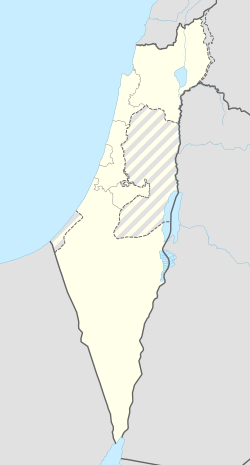
המושב נמצא בגובה 288 מטרים על מדרונות מיוערים בקצה המערבי של הרי יהודה ובאזור פרוזדור ירושלים. צפונית למושב ישנו יער של הקרן הקיימת המהווה חלק מיער פארק רבין. שטחו כ-1,800 דונם וההתיישבות בו היא ברובה יהודית אתנית דתית. תרום ממוקם כ-5 קילומטרים מהקו הירוק.
ליד המושב ניצבת אנדרטת גדוד 184.
היסטוריה
תרום נוסד ב-9 במאי 1950 (כ"ב באייר ה'תש"י), ושמו לקוח מן הפסוק:
לְךָ זְרוֹעַ עִם גְּבוּרָה, תָּעֹז יָדְךָ, תָּרוּם יְמִינֶךָ.
גם שם המושב השכן, תעוז, נגזר מפסוק זה.[3]
המושב הוקם בשנת 1949 על ידי עולים מתימן בשני גלי עלייה, שהיו חלק ממבצע על כנפי נשרים. לאחר מספר שנים הצטרפו אליהם עולים מהודו, ובפרט מקוצ'ין. בשנת 2013 הוקמה הרחבה במושב. ההרחבה מונה כ-50 משפחות מהמגזר הדתי לאומי.[4]
אוכלוסייה
נכון לסוף 2009 מספר התושבים עומד על 568[5]
טבלת צמיחת האוכלוסייה לאורך השנים:
| שנה | 1961 | 1972 | 1983 | 1995 | 2001 | 2003 | 2004 | 2005 | 2006 | 2007 | 2008 | 2009 |
|---|---|---|---|---|---|---|---|---|---|---|---|---|
| אוכלוסייה | 304 | 376 | 362 | 422 | 478 | 484 | 471 | 475 | 488 | 482 | 511 | 568 |
קישורים חיצוניים
הערות שוליים
- ^ 1 2 אוכלוסייה בעיריות, במועצות המקומיות והאזוריות וביישובים בעלי 2,000 תושבים לפחות - לפי טבלה חודשית של למ"ס עבור סוף דצמבר 2024 (אומדן), בכל יתר היישובים - לפי טבלה שנתית של למ"ס עבור סוף 2023.
- ^ הנתונים לפי טבלת מדד חברתי כלכלי של למ"ס נכון לשנת 2021
- ^ יואב רגב, מדריך ישראל החדש, כרך 10: השפלה, כתר, ידיעות אחרונות ומשרד הביטחון, 2001
- ^ תרום באתר תנועת העבודה הישראלית
- ^ קובץ מפקד האוכלוסין של תרום באתר הלשכה המרכזית לסטטיסטיקה
-
תרום ממעוף הציפור
-
מבט אל המושב
-
מבנים פרטיים במושב
-
השביל המרכזי בכניסה למושב
-
תרום – תצפית מכיוון תל צרעה
-
תרום וסביבותיה – תצפית מכיוון תל צרעה


