גורן (מושב)
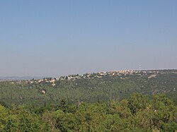
גורן (גֹּרֶן) הוא מושב באזור הגליל המערבי ליד העיר מעלות תרשיחא השייך למועצה אזורית מעלה יוסף.
 | |
| מדינה | |
| מחוז | הצפון |
| מועצה אזורית | מעלה יוסף |
| גובה ממוצע[1] | 368 מטר |
| תאריך ייסוד | 1950 |
| תנועה מיישבת | תנועת המושבים |
| סוג יישוב | מושב |
| נתוני אוכלוסייה לפי הלמ"ס לסוף 2023[1] | |
| - אוכלוסייה | 428 תושבים |
| - מתוכם, תושבי ישראל | 409 תושבי ישראל |
<mapframe align="center" height="350" latitude="33.02957279478" longitude="35.268994926439" text="<div style="text-align:center;">מפת היישובים של מועצה אזורית מעלה יוסף<br />באדום - גורן<br />בירוק - מיקום בניין המועצה</div>" width="350" zoom="11">[{"properties":{"title":"geomask1","marker-color":"#0000FF"},"type":"ExternalData","service":"geomask","ids":"Q2436968"},{"features":[{"type":"Feature","geometry":{"coordinates":[35.2884285901586,33.1000753391237],"type":"Point"},"properties":{"title":"כפר רוזנואלד (זרעית)","marker-color":"#0000FF"}},{"type":"Feature","geometry":{"coordinates":[35.3142274118729,33.0852681505385],"type":"Point"},"properties":{"title":"שתולה","marker-color":"#0000FF"}},{"type":"Feature","geometry":{"coordinates":[35.2836999606391,33.0832175027644],"type":"Point"},"properties":{"title":"שומרה","marker-color":"#0000FF"}},{"type":"Feature","geometry":{"coordinates":[35.2940800866093,33.0742840735125],"type":"Point"},"properties":{"title":"אבן מנחם","marker-color":"#0000FF"}},{"type":"Feature","geometry":{"coordinates":[35.1865589462461,33.0674623913372],"type":"Point"},"properties":{"title":"יערה","marker-color":"#0000FF"}},{"type":"Feature","geometry":{"coordinates":[35.3235180635447,33.0647018546551],"type":"Point"},"properties":{"title":"נטועה","marker-color":"#0000FF"}},{"type":"Feature","geometry":{"coordinates":[35.247027,33.061827],"type":"Point"},"properties":{"title":"בניין מועצה אזורית מעלה יוסף","marker-color":"#00FF00"}},{"type":"Feature","geometry":{"coordinates":[35.2492004113542,33.0599719041368],"type":"Point"},"properties":{"title":"גורנות הגליל","marker-color":"#0000FF"}},{"type":"Feature","geometry":{"coordinates":[35.2363499935507,33.0566397118891],"type":"Point"},"properties":{"title":"גורן","marker-color":"#FF0000"}},{"type":"Feature","geometry":{"coordinates":[35.180460347876,33.0479855175853],"type":"Point"},"properties":{"title":"עבדון","marker-color":"#0000FF"}},{"type":"Feature","geometry":{"coordinates":[35.3575295050011,33.0411314123806],"type":"Point"},"properties":{"title":"מתת","marker-color":"#0000FF"}},{"type":"Feature","geometry":{"coordinates":[35.1947006565775,33.038790505701],"type":"Point"},"properties":{"title":"מנות","marker-color":"#0000FF"}},{"type":"Feature","geometry":{"coordinates":[35.2868714519019,33.0384931746318],"type":"Point"},"properties":{"title":"אבירים","marker-color":"#0000FF"}},{"type":"Feature","geometry":{"coordinates":[35.2442643056929,33.0364402301933],"type":"Point"},"properties":{"title":"מצפה הילה","marker-color":"#0000FF"}},{"type":"Feature","geometry":{"coordinates":[35.3237970029429,33.0333238205845],"type":"Point"},"properties":{"title":"אלקוש","marker-color":"#0000FF"}},{"type":"Feature","geometry":{"coordinates":[35.1837842008214,33.0269773806664],"type":"Point"},"properties":{"title":"נווה זיו","marker-color":"#0000FF"}},{"type":"Feature","geometry":{"coordinates":[35.2609509706916,33.0162365182341],"type":"Point"},"properties":{"title":"מעונה","marker-color":"#0000FF"}},{"type":"Feature","geometry":{"coordinates":[35.2294840333785,33.0094842996632],"type":"Point"},"properties":{"title":"עין יעקב","marker-color":"#0000FF"}},{"type":"Feature","geometry":{"coordinates":[35.3138091627418,33.0068240518574],"type":"Point"},"properties":{"title":"צוריאל","marker-color":"#0000FF"}},{"type":"Feature","geometry":{"coordinates":[35.2974268122212,32.9978206692716],"type":"Point"},"properties":{"title":"חוסן","marker-color":"#0000FF"}},{"type":"Feature","geometry":{"coordinates":[35.3229813798794,32.9837329770616],"type":"Point"},"properties":{"title":"פקיעין החדשה","marker-color":"#0000FF"}},{"type":"Feature","geometry":{"coordinates":[35.2489396694538,32.9671004194114],"type":"Point"},"properties":{"title":"גיתה","marker-color":"#0000FF"}},{"type":"Feature","geometry":{"coordinates":[35.2618772012981,32.9590702504367],"type":"Point"},"properties":{"title":"לפידות","marker-color":"#0000FF"}}],"type":"FeatureCollection"}]</mapframe>
| |
| מדד חברתי-כלכלי - אשכול לשנת 2021[2] |
2 מתוך 10 |

היסטוריה
היישוב שראשיתו כפר עבודה הוקם בשנת 1950 על ידי עולים מתימן[3] שנשארו במקום כשנה, לאחר כשנה עברו חלק מהם לנתניה וחלק אחר לאזור ובודדים התפזרו למקומות שונים אחרים ובמקומם הגיעו לכפר עולים יוצאי צפון אפריקה. הכפר הפך למושב והיום הוא מושב מצליח.
שמו של היישוב הוא שם סמלי, בהוראה שאולה, בעקבות הכתוב בספר מיכה: "כִּי קִבְּצָם כֶּעָמִיר גֹּרְנָה" ובתרגום שם המקום מ"בידר אלכואב" בערבית ל"גורן הכיפות" בעברית. משום תצורת הקרקע הגבנונית במקום.
כפרי עבודה הייתה צורת יישוב לפיה הביאו קבוצות עולים לעבד קרקע ולפתח חורש במקום שנבחר לכך, בדרך כלל באזורי ספר. כעבור מספר חודשים או שנים, בחרו אם להישאר או לעבור למקום אחר.
בראשית שנות החמישים היו כ-21 כפרי עבודה שמרביתם הפכו למושבים ועודם כאלה.
כפרי העבודה הוקמו על ידי המחלקה להתיישבות בסוכנות היהודית, בניהולו של רענן ויץ, על פי תפיסתו של יוסף ויץ (ראש הקרן הקיימת דאז ואביו של רענן) ולוי אשכול (השר הממונה על המחלקה להתיישבות).
קישורים חיצוניים
- גורן, במרכז המידע לנגב ולגליל של תנועת אור
- מידע על גורן (מושב) בקטלוג הספרייה הלאומית
הערות שוליים
- ^ 1 2 אוכלוסייה בעיריות, במועצות המקומיות והאזוריות וביישובים בעלי 2,000 תושבים לפחות - לפי טבלה חודשית של למ"ס עבור סוף דצמבר 2024 (אומדן), בכל יתר היישובים - לפי טבלה שנתית של למ"ס עבור סוף 2023.
- ^ הנתונים לפי טבלת מדד חברתי כלכלי של למ"ס נכון לשנת 2021
- ^ ענבר שחר, ישובי מעלה יוסף פינה לתפארת על גבול הלבנון, מעריב, 3 בינואר 1988


