אחווה (מרכז כפרי)
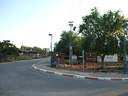
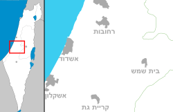
אחווה (אַחֲוָה) הוא יישוב ומרכז כפרי בתחום מועצה אזורית באר טוביה. הוקם בשנת 1974. ביישוב שתי שכונות: אחווה ונאות אחוה. המרכז הכפרי נמצא סמוך למכללת אחווה וליישובים ערוגות, ינון, כפר אחים, תלמי יחיאל, כפר הרי"ף. מטרת המרכז הכפרי שהוקם על ידי המועצה הייתה מתן שירותים (גנים, מרפאה וצרכנייה) למושבים שמסביב[3]. עם הזמן, הרעיון דעך ואחווה הפך ליישוב קהילתי בפני עצמו.

| |
| מדינה | |
| מחוז | הדרום |
| מועצה אזורית | באר טוביה |
| גובה ממוצע[1] | 61 מטר |
| תאריך ייסוד | 1974 |
| סוג יישוב | יישוב כפרי אחר |
| נתוני אוכלוסייה לפי הלמ"ס לסוף 2023[1] | |
| - אוכלוסייה | 291 תושבים |
| - מתוכם, תושבי ישראל | 251 תושבי ישראל |
<mapframe align="center" height="320" latitude="31.74" longitude="34.71" text="<div style="text-align:center;">מפת היישובים של מועצה אזורית באר טוביה<br />באדום - אחווה<br />בירוק - מיקום בניין המועצה</div>" width="320" zoom="11">[{"properties":{"title":"geomask1","marker-color":"#0000FF"},"type":"ExternalData","service":"geomask","ids":"Q2800164"},{"features":[{"type":"Feature","geometry":{"coordinates":[34.7411584621055,31.8056135632855],"type":"Point"},"properties":{"title":"נווה מבטח","marker-color":"#0000FF"}},{"type":"Feature","geometry":{"coordinates":[34.7521589999819,31.8019556962227],"type":"Point"},"properties":{"title":"כנות","marker-color":"#0000FF"}},{"type":"Feature","geometry":{"coordinates":[34.7292740196611,31.7961005158213],"type":"Point"},"properties":{"title":"ביצרון","marker-color":"#0000FF"}},{"type":"Feature","geometry":{"coordinates":[34.7697856493061,31.7811849366582],"type":"Point"},"properties":{"title":"חצב","marker-color":"#0000FF"}},{"type":"Feature","geometry":{"coordinates":[34.6835725262199,31.773736566254],"type":"Point"},"properties":{"title":"שתולים","marker-color":"#0000FF"}},{"type":"Feature","geometry":{"coordinates":[34.7203154850933,31.7726191943561],"type":"Point"},"properties":{"title":"חצור אשדוד","marker-color":"#0000FF"}},{"type":"Feature","geometry":{"coordinates":[34.6777585365014,31.7564877109936],"type":"Point"},"properties":{"title":"שדה עוזיהו","marker-color":"#0000FF"}},{"type":"Feature","geometry":{"coordinates":[34.7628446081627,31.7532943953995],"type":"Point"},"properties":{"title":"תלמי יחיאל","marker-color":"#0000FF"}},{"type":"Feature","geometry":{"coordinates":[34.7247459498742,31.7527957028419],"type":"Point"},"properties":{"title":"מחנה מרים","marker-color":"#0000FF"}},{"type":"Feature","geometry":{"coordinates":[34.6971041633482,31.7508848065108],"type":"Point"},"properties":{"title":"עזריקם","marker-color":"#0000FF"}},{"type":"Feature","geometry":{"coordinates":[34.7569759061161,31.7446162739312],"type":"Point"},"properties":{"title":"כפר אחים","marker-color":"#0000FF"}},{"type":"Feature","geometry":{"coordinates":[34.676248088223,31.7436754664998],"type":"Point"},"properties":{"title":"אמונים","marker-color":"#0000FF"}},{"type":"Feature","geometry":{"coordinates":[34.7691171657255,31.7435761920935],"type":"Point"},"properties":{"title":"אחווה","marker-color":"#FF0000"}},{"type":"Feature","geometry":{"coordinates":[34.7814688179373,31.7426258333982],"type":"Point"},"properties":{"title":"ינון","marker-color":"#0000FF"}},{"type":"Feature","geometry":{"coordinates":[34.7345094701208,31.7421905073784],"type":"Point"},"properties":{"title":"אורות","marker-color":"#0000FF"}},{"type":"Feature","geometry":{"coordinates":[34.655389967711,31.7373645430533],"type":"Point"},"properties":{"title":"בית עזרא","marker-color":"#0000FF"}},{"type":"Feature","geometry":{"coordinates":[34.725559,31.737136],"type":"Point"},"properties":{"title":"בניין מועצה אזורית באר טוביה","marker-color":"#00FF00"}},{"type":"Feature","geometry":{"coordinates":[34.6712219374913,31.7368005882307],"type":"Point"},"properties":{"title":"עזר","marker-color":"#0000FF"}},{"type":"Feature","geometry":{"coordinates":[34.7230478777266,31.7342115171697],"type":"Point"},"properties":{"title":"באר טוביה","marker-color":"#0000FF"}},{"type":"Feature","geometry":{"coordinates":[34.772432168514,31.7342083863795],"type":"Point"},"properties":{"title":"ערוגות","marker-color":"#0000FF"}},{"type":"Feature","geometry":{"coordinates":[34.6805291855125,31.7330515537029],"type":"Point"},"properties":{"title":"גבעתי","marker-color":"#0000FF"}},{"type":"Feature","geometry":{"coordinates":[34.7266077882192,31.7190740871671],"type":"Point"},"properties":{"title":"כפר ורבורג","marker-color":"#0000FF"}},{"type":"Feature","geometry":{"coordinates":[34.7585928780492,31.7154925993901],"type":"Point"},"properties":{"title":"תימורים","marker-color":"#0000FF"}},{"type":"Feature","geometry":{"coordinates":[34.7430049484612,31.7102063818153],"type":"Point"},"properties":{"title":"אביגדור","marker-color":"#0000FF"}},{"type":"Feature","geometry":{"coordinates":[34.7548999322339,31.6718304381919],"type":"Point"},"properties":{"title":"ניר בנים","marker-color":"#0000FF"}}],"type":"FeatureCollection"}]</mapframe>
| |
| מדד חברתי-כלכלי - אשכול לשנת 2021[2] |
7 מתוך 10 |
על פי נתוני הלשכה המרכזית לסטטיסטיקה, אחווה הוא היישוב הכפרי עם שיעור הילדים הנמוך ביותר בישראל - 2.5%[4].
אחווה מורכב משתי שכונות: שכונת אחווה ובה כ-30 יחידות דיור ונאות אחווה שבה 80 יחידות דיור מוגן.
האירוע המרכזי של הכפר נחגג בל'ג בעומר ומכונה "חג הכפר" .
הערות שוליים
- ^ 1 2 אוכלוסייה בעיריות, במועצות המקומיות והאזוריות וביישובים בעלי 2,000 תושבים לפחות - לפי טבלה חודשית של למ"ס עבור סוף דצמבר 2024 (אומדן), בכל יתר היישובים - לפי טבלה שנתית של למ"ס עבור סוף 2023.
- ^ הנתונים לפי טבלת מדד חברתי כלכלי של למ"ס נכון לשנת 2021
- ^ https://www.homee.co.il/%D7%90%D7%97%D7%95%D7%95%D7%94/
- ^ משה כהן, נתוני הלמ"ס: בית שמש מובילה במספר הילדים למשפחה, ת"א בתחתית הרשימה, באתר מעריב אונליין, 18 בנובמבר 2019


