ענבר (יישוב)
| מדינה | |
| מחוז | הצפון |
| מועצה אזורית | מרום הגליל |
| תאריך ייסוד | 1994 |
| סוג יישוב | קיבוץ |
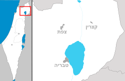
<mapframe align="left" height="500" latitude="32.976217901491" longitude="35.438775692913" text="<center>מפת היישובים של מועצה אזורית מרום הגליל<br />באדום - ענבר<br />בירוק - מיקום בניין המועצה</center>" width="320" zoom="11">[{"properties":{"title":"geomask1","fill-opacity":0.5},"type":"ExternalData","service":"geomask","ids":"Q680095"},{"features":[{"type":"Feature","geometry":{"coordinates":[35.471792330828,33.0886361895158],"type":"Point"},"properties":{"fill-opacity":0.5,"title":"אביבים","marker-color":"#0000FF"}},{"type":"Feature","geometry":{"coordinates":[35.4072268931609,33.0517901990303],"type":"Point"},"properties":{"fill-opacity":0.5,"title":"דוב\"ב","marker-color":"#0000FF"}},{"type":"Feature","geometry":{"coordinates":[35.4998376032644,33.0512443886372],"type":"Point"},"properties":{"fill-opacity":0.5,"title":"עלמה","marker-color":"#0000FF"}},{"type":"Feature","geometry":{"coordinates":[35.487412306849,33.0494699166353],"type":"Point"},"properties":{"fill-opacity":0.5,"title":"ריחאניה","marker-color":"#0000FF"}},{"type":"Feature","geometry":{"coordinates":[35.467679211108,33.0382424499919],"type":"Point"},"properties":{"fill-opacity":0.5,"title":"כרם בן זמרה","marker-color":"#0000FF"}},{"type":"Feature","geometry":{"coordinates":[35.4891277172792,33.0169161371473],"type":"Point"},"properties":{"fill-opacity":0.5,"title":"דלתון","marker-color":"#0000FF"}},{"type":"Feature","geometry":{"coordinates":[35.4402046874398,33.0120591184682],"type":"Point"},"properties":{"fill-opacity":0.5,"title":"כפר חושן","marker-color":"#0000FF"}},{"type":"Feature","geometry":{"coordinates":[35.4470350820416,33.0051933735951],"type":"Point"},"properties":{"fill-opacity":0.5,"title":"אור הגנוז","marker-color":"#0000FF"}},{"type":"Feature","geometry":{"coordinates":[35.4639420633063,33.004978999276],"type":"Point"},"properties":{"fill-opacity":0.5,"title":"כדיתה","marker-color":"#0000FF"}},{"type":"Feature","geometry":{"coordinates":[35.5248056814106,32.9980750013173],"type":"Point"},"properties":{"fill-opacity":0.5,"title":"עמוקה","marker-color":"#0000FF"}},{"type":"Feature","geometry":{"coordinates":[35.4488338663647,32.9977962137012],"type":"Point"},"properties":{"fill-opacity":0.5,"title":"בר יוחאי","marker-color":"#0000FF"}},{"type":"Feature","geometry":{"coordinates":[35.440579,32.997762],"type":"Point"},"properties":{"fill-opacity":0.5,"title":"בניין מועצה אזורית מרום הגליל","marker-color":"#00FF00"}},{"type":"Feature","geometry":{"coordinates":[35.4400313054607,32.9870833312835],"type":"Point"},"properties":{"fill-opacity":0.5,"title":"מירון","marker-color":"#0000FF"}},{"type":"Feature","geometry":{"coordinates":[35.5002352151782,32.9779384207016],"type":"Point"},"properties":{"fill-opacity":0.5,"title":"ביריה","marker-color":"#0000FF"}},{"type":"Feature","geometry":{"coordinates":[35.4571700646311,32.9567537238354],"type":"Point"},"properties":{"fill-opacity":0.5,"title":"כפר שמאי","marker-color":"#0000FF"}},{"type":"Feature","geometry":{"coordinates":[35.436173280395,32.9436300726205],"type":"Point"},"properties":{"fill-opacity":0.5,"title":"שפר","marker-color":"#0000FF"}},{"type":"Feature","geometry":{"coordinates":[35.3993806829783,32.9406272695829],"type":"Point"},"properties":{"fill-opacity":0.5,"title":"עין אל-אסד","marker-color":"#0000FF"}},{"type":"Feature","geometry":{"coordinates":[35.451554181938,32.9371986878772],"type":"Point"},"properties":{"fill-opacity":0.5,"title":"אמירים","marker-color":"#0000FF"}},{"type":"Feature","geometry":{"coordinates":[35.3527457044157,32.9332074781462],"type":"Point"},"properties":{"fill-opacity":0.5,"title":"שזור","marker-color":"#0000FF"}},{"type":"Feature","geometry":{"coordinates":[35.4333634632448,32.9321839997373],"type":"Point"},"properties":{"fill-opacity":0.5,"title":"פרוד","marker-color":"#0000FF"}},{"type":"Feature","geometry":{"coordinates":[35.4232706571562,32.9150702527612],"type":"Point"},"properties":{"fill-opacity":0.5,"title":"כפר חנניה","marker-color":"#0000FF"}},{"type":"Feature","geometry":{"coordinates":[35.423,32.910297],"type":"Point"},"properties":{"fill-opacity":0.5,"title":"ענבר","marker-color":"#0000FF"}},{"type":"Feature","geometry":{"coordinates":[35.3949234559256,32.9065507654806],"type":"Point"},"properties":{"fill-opacity":0.5,"title":"חזון","marker-color":"#0000FF"}},{"type":"Feature","geometry":{"coordinates":[35.4556561089418,32.8751550630913],"type":"Point"},"properties":{"fill-opacity":0.5,"title":"כלנית","marker-color":"#0000FF"}},{"type":"Feature","geometry":{"coordinates":[35.4221947400709,32.8685454033022],"type":"Point"},"properties":{"fill-opacity":0.5,"title":"טפחות","marker-color":"#0000FF"}},{"type":"Feature","geometry":{"coordinates":[35.4946206966984,32.8637996134657],"type":"Point"},"properties":{"fill-opacity":0.5,"title":"ליבנים","marker-color":"#0000FF"}}],"type":"FeatureCollection"}]</mapframe>
| |
| אתר היישוב | |
עִנְבָּר הוא יישוב שיתופי לא מוכר בגליל, סמוך לכרמיאל, שייך למועצה אזורית מרום הגליל. ענבר הוא היישוב השיתופי השני הקטן ביותר בישראל אחרי עיר אובות, ובו כעשרים תושבים בלבד.[1]
שורשים והיסטוריה
באזור בו עומד היישוב שכן בתקופת המקרא כפר חנניה - יישוב יהודי שהתקיים ברציפות מימי בית ראשון ועד המאה ה-16 לספירה. היישוב המקראי היה ממוקם על גדות נחל צלמון, והיה ידוע בזכות כדי החרס שייצר שנחשבו לאיכותיים. רבי חלפתא, תנא מהדור השלישי לתנאים חי באזור וקבור במקום.
במאה ה-16 ננטש היישוב ותושביו עקרו לפקיעין שם התקיים יישוב יהודי גדול יותר.
הקמת היישוב
בסוף שנות ה-70, במסגרת תוכנית המצפים, הוקם במקום מחנה התיישבות זמני למקימי מושבים. שרידי המבנים ששמשו את המחנה שופצו על ידי חברי היישוב כשאלה עלו להתיישב בו ביום העצמאות, מאי 1994.
ענפי המשק
כל חברי היישוב מתקיימים מענף התיירות, ועובדים בבית ההארחה שמפעיל היישוב. היישוב מארח בעיקר קבוצות ומפעיל סדנאות שונות בנושאי בריאות ומודעות.
קישורים חיצוניים
- איל שפירא, הפתעות גליליות בקיבוץ הכי קטן בעולם, באתר וואלה, 13 בנובמבר 2015
הערות שוליים
| ||||||||||||||||


