חרמש (יישוב)
 | |
| מדינה | |
| מחוז | יהודה ושומרון |
| מועצה אזורית | שומרון |
| גובה ממוצע[1] | 238 מטר |
| תאריך ייסוד | 1984 |
| תנועה מיישבת | חרות בית"ר |
| סוג יישוב | יישוב קהילתי |
| נתוני אוכלוסייה לפי הלמ"ס לסוף 2023[1] | |
| - אוכלוסייה | 284 תושבים |
| - מתוכם, תושבי ישראל | 283 תושבי ישראל |
<mapframe align="center" height="460" latitude="32.26" longitude="35.176045089962" text="<div style="text-align:center;">מפת היישובים של מועצה אזורית שומרון<br />באדום - חרמש<br />בירוק - מיקום בניין המועצה</div>" width="300" zoom="10">[{"properties":{"title":"geoshape1","marker-color":"#0000FF"},"type":"ExternalData","service":"geoshape","ids":"Q2423990"},{"features":[{"type":"Feature","geometry":{"coordinates":[35.1685906788509,32.4811729134093],"type":"Point"},"properties":{"title":"חיננית","marker-color":"#0000FF"}},{"type":"Feature","geometry":{"coordinates":[35.1686999217281,32.473958999594],"type":"Point"},"properties":{"title":"שקד","marker-color":"#0000FF"}},{"type":"Feature","geometry":{"coordinates":[35.1360453672132,32.4695269090195],"type":"Point"},"properties":{"title":"ריחן","marker-color":"#0000FF"}},{"type":"Feature","geometry":{"coordinates":[35.1190692968561,32.4234372327569],"type":"Point"},"properties":{"title":"חרמש","marker-color":"#FF0000"}},{"type":"Feature","geometry":{"coordinates":[35.1756316117026,32.4202166311262],"type":"Point"},"properties":{"title":"מבוא דותן","marker-color":"#0000FF"}},{"type":"Feature","geometry":{"coordinates":[35.0735513969773,32.2855190032994],"type":"Point"},"properties":{"title":"אבני חפץ","marker-color":"#0000FF"}},{"type":"Feature","geometry":{"coordinates":[35.1264184382911,32.2844807068292],"type":"Point"},"properties":{"title":"ענב","marker-color":"#0000FF"}},{"type":"Feature","geometry":{"coordinates":[35.1845963730235,32.263582201139],"type":"Point"},"properties":{"title":"שבי שומרון","marker-color":"#0000FF"}},{"type":"Feature","geometry":{"coordinates":[35.0500574879728,32.2424778696786],"type":"Point"},"properties":{"title":"סלעית","marker-color":"#0000FF"}},{"type":"Feature","geometry":{"coordinates":[35.3349404308889,32.2326756408801],"type":"Point"},"properties":{"title":"אלון מורה","marker-color":"#0000FF"}},{"type":"Feature","geometry":{"coordinates":[35.0098316357078,32.1980547495095],"type":"Point"},"properties":{"title":"צופים","marker-color":"#0000FF"}},{"type":"Feature","geometry":{"coordinates":[35.265527176795,32.1925088563607],"type":"Point"},"properties":{"title":"ברכה","marker-color":"#0000FF"}},{"type":"Feature","geometry":{"coordinates":[35.3076079096752,32.1741752867726],"type":"Point"},"properties":{"title":"איתמר","marker-color":"#0000FF"}},{"type":"Feature","geometry":{"coordinates":[35.23677953646,32.1687123306554],"type":"Point"},"properties":{"title":"יצהר","marker-color":"#0000FF"}},{"type":"Feature","geometry":{"coordinates":[35.320672428242794,32.4510426782529],"type":"Point"},"properties":{"title":"כדים","marker-color":"#0000FF"}},{"type":"Feature","geometry":{"coordinates":[35.1017254478,32.1535245954859],"type":"Point"},"properties":{"title":"נופים","marker-color":"#0000FF"}},{"type":"Feature","geometry":{"coordinates":[35.1146616018142,32.1497469406147],"type":"Point"},"properties":{"title":"יקיר","marker-color":"#0000FF"}},{"type":"Feature","geometry":{"coordinates":[35.37062883554597,32.21375670692334],"type":"Point"},"properties":{"title":"חוות סקאלי","marker-color":"#0000FF"}},{"type":"Feature","geometry":{"coordinates":[35.237796681103355,32.11729008223913],"type":"Point"},"properties":{"title":"טל בנימין","marker-color":"#0000FF"}},{"type":"Feature","geometry":{"coordinates":[35.1283613604406,32.1186441145099],"type":"Point"},"properties":{"title":"רבבה","marker-color":"#0000FF"}},{"type":"Feature","geometry":{"coordinates":[35.2509608762186,32.1183879814675],"type":"Point"},"properties":{"title":"כפר תפוח","marker-color":"#0000FF"}},{"type":"Feature","geometry":{"coordinates":[35.1124687686999,32.116739775824],"type":"Point"},"properties":{"title":"קריית נטפים","marker-color":"#0000FF"}},{"type":"Feature","geometry":{"coordinates":[35.117,32.111],"type":"Point"},"properties":{"title":"בניין מועצה אזורית שומרון","marker-color":"#00FF00"}},{"type":"Feature","geometry":{"coordinates":[35.1089834173669,32.1058254701235],"type":"Point"},"properties":{"title":"ברקן","marker-color":"#0000FF"}},{"type":"Feature","geometry":{"coordinates":[35.2570974817548,32.1022434373135],"type":"Point"},"properties":{"title":"רחלים","marker-color":"#0000FF"}},{"type":"Feature","geometry":{"coordinates":[35.3422585442171,32.0900952886563],"type":"Point"},"properties":{"title":"מגדלים","marker-color":"#0000FF"}},{"type":"Feature","geometry":{"coordinates":[35.0865544580354,32.0808267520457],"type":"Point"},"properties":{"title":"ברוכין","marker-color":"#0000FF"}},{"type":"Feature","geometry":{"coordinates":[35.0658092200484,32.0708859149209],"type":"Point"},"properties":{"title":"עלי זהב","marker-color":"#0000FF"}},{"type":"Feature","geometry":{"coordinates":[35.0521624954767,32.061581673904],"type":"Point"},"properties":{"title":"פדואל","marker-color":"#0000FF"}},{"type":"Feature","geometry":{"coordinates":[35.06426766191313,32.091080533383405],"type":"Point"},"properties":{"title":"שחרית (יישוב)","marker-color":"#0000FF"}},{"type":"Feature","geometry":{"coordinates":[35.275429505451584,32.12045057300386],"type":"Point"},"properties":{"title":"אביתר (מאחז)","marker-color":"#0000FF"}},{"type":"Feature","geometry":{"coordinates":[35.19170425032363,32.30782933366331],"type":"Point"},"properties":{"title":"חומש (יישוב)","marker-color":"#0000FF"}},{"type":"Feature","geometry":{"coordinates":[35.235941861562615,32.09820433081714],"type":"Point"},"properties":{"title":"נופי נחמיה","marker-color":"#0000FF"}},{"type":"Feature","geometry":{"coordinates":[35.366691329106246,32.15349336108011],"type":"Point"},"properties":{"title":"גבעת ארנון","marker-color":"#0000FF"}},{"type":"Feature","geometry":{"coordinates":[35.35239780072268,32.15960956115372],"type":"Point"},"properties":{"title":"גבעות עולם","marker-color":"#0000FF"}},{"type":"Feature","geometry":{"coordinates":[35.33815214635056,32.449660538412815],"type":"Point"},"properties":{"title":"גנים","marker-color":"#0000FF"}},{"type":"Feature","geometry":{"coordinates":[35.20204290107121,32.336591249759294],"type":"Point"},"properties":{"title":"שא נור","marker-color":"#0000FF"}},{"type":"Feature","geometry":{"coordinates":[35.18153442282832,32.19925265984604],"type":"Point"},"properties":{"title":"חוות גלעד","marker-color":"#0000FF"}},{"type":"Feature","geometry":{"coordinates":[35.16055385309542,32.483582714727135],"type":"Point"},"properties":{"title":"טל מנשה","marker-color":"#0000FF"}},{"type":"Feature","geometry":{"coordinates":[35.10514848582239,32.14525666830592],"type":"Point"},"properties":{"title":"חוות יאיר","marker-color":"#0000FF"}}],"type":"FeatureCollection"}]</mapframe>
| |
| מדד חברתי-כלכלי - אשכול לשנת 2021[2] |
5 מתוך 10 |
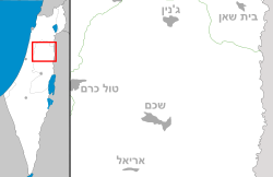
חרמש היא התנחלות ויישוב קהילתי בצפון-מערב השומרון בין העיירות הפלסטיניות יעבד וקפין, השייך למועצה אזורית שומרון.
היסטוריה
חרמש הוקמה ב-1983 כהיאחזות נח"ל[3], ובאפריל אותה שנה אוזרחה, למרות התנגדותו של רענן ויץ, שטען שאין במקום מספיק קרקעות ואין גרעין התיישבותי מתאים לאזרוח המקום[4]. בנובמבר 1983 הוחל בבניית בתים במקום[5]. התנועה המיישבת של חרמש הייתה תנועת חרות-בית"ר.
שמו של היישוב הוא על שם כלי העבודה החקלאי חרמש.
תושבי המקום כללו עולים מברית המועצות יחד עם ילידי ישראל[6].
באוקטובר 2002, נרצחו בפיגוע ביישוב שלוש מתושבות היישוב, אורנה אשל, הדס תורג'מן ולינוי סרוסי[7].
במהלך הכנת תוכנית ההתנתקות הוצע לפנות את היישוב ואת מבוא דותן יחד עם ארבעת היישובים שפונו בצפון השומרון (גנים, כדים, שא-נור וחומש),[8] אך לבסוף הוחלט שלא לפנותם.
ב-30 במאי 2023 נרצח בפיגוע ירי בכניסה ליישוב מאיר תמרי בן 32 תושב היישוב.
ביישוב בריכת שחיה, גן ילדים, גן שעשועים, מגרש ספורט, מקווה ומועדון נוער.
ביישוב מתגוררות כ-70 משפחות.
ביישוב מתוכננת תוכנית "חרמש צפון" להכפלת היישוב בבניית יחידות דיור בצידה הצפונה של היישוב.
אתר ארכאולוגי חורבת פרסין נמצא כקילומטר מערבית מחרמש.
קישורים חיצוניים
- חרמש - באתר המועצה האזורית שומרון
הערות שוליים
- ^ 1 2 אוכלוסייה בעיריות, במועצות המקומיות והאזוריות וביישובים בעלי 2,000 תושבים לפחות - לפי טבלה חודשית של למ"ס עבור סוף דצמבר 2024 (אומדן), בכל יתר היישובים - לפי טבלה שנתית של למ"ס עבור סוף 2023.
- ^ הנתונים לפי טבלת מדד חברתי כלכלי של למ"ס נכון לשנת 2021
- ^ על הפרק - פרקי נח"ל, דבר, 8 ביוני 1983
- ^ טובה צימוקי, מחלוקת קשה בין לוי לדרובלס: מי יהיה אחראי להתיישבות ביו"ש, דבר, 20 באפריל 1983
- ^ 2400 התחלות בנייה ביו"ש עד אפריל, דבר, 20 בנובמבר 1983
- ^ שומרון, מעריב, 21 באוגוסט 1985
- ^ אפרת וייס ופליקס פריש, הפתח נטל אחריות לפיגוע בחרמש, באתר ynet, 30 באוקטובר 2002
- ^ רוב הבתים בחרמש כבר נטושים; עכשיו, אחרי רצח ייבגני ריידר, מחכים, באתר הארץ, 22 ביוני 2005
| ||||||||||||||||


