תדהר
תִּדְהָר הוא מושב בנגב הצפוני-מערבי, מדרום מזרח לנתיבות, ומצפון מזרח לאופקים. המושב שייך לשלושת מושבי "יחדיו" אשר הוקמו בסמיכות זה לזה, כחלק ממועצה אזורית בני שמעון על ידי תנועת המושבים.
 בית הכנסת מושב תדהר בית הכנסת מושב תדהר
| |
| מדינה | |
| מחוז | הדרום |
| מועצה אזורית | בני שמעון |
| גובה ממוצע[1] | 115 מטר |
| תאריך ייסוד | 1953 |
| תנועה מיישבת | תנועת המושבים |
| סוג יישוב | מושב |
| נתוני אוכלוסייה לפי הלמ"ס לסוף 2023[1] | |
| - אוכלוסייה | 773 תושבים |
| - מתוכם, תושבי ישראל | 689 תושבי ישראל |
(למפת מערב הנגב רגילה)  תִּדְהָר
<mapframe align="center" height="600" latitude="31.33" longitude="34.78" text="<div style="text-align:center;">מפת היישובים של מועצה אזורית בני שמעון<br />באדום - תדהר<br />בירוק - מיקום בניין המועצה</div>" width="500" zoom="11">[{"properties":{"title":"geomask1","marker-color":"#0000FF"},"type":"ExternalData","service":"geomask","ids":"Q794964"},{"features":[{"type":"Feature","geometry":{"coordinates":[34.7614409433851,31.4483720567021],"type":"Point"},"properties":{"title":"בית קמה","marker-color":"#0000FF"}},{"type":"Feature","geometry":{"coordinates":[34.761035,31.442291],"type":"Point"},"properties":{"title":"בניין מועצה אזורית בני שמעון","marker-color":"#00FF00"}},{"type":"Feature","geometry":{"coordinates":[34.8837391309649,31.4322327264805],"type":"Point"},"properties":{"title":"שומרייה","marker-color":"#0000FF"}},{"type":"Feature","geometry":{"coordinates":[34.7440412197474,31.4138588385457],"type":"Point"},"properties":{"title":"שובל","marker-color":"#0000FF"}},{"type":"Feature","geometry":{"coordinates":[34.8249165856152,31.41241066273],"type":"Point"},"properties":{"title":"דביר (דבירה)","marker-color":"#0000FF"}},{"type":"Feature","geometry":{"coordinates":[34.8688852893614,31.3796145250004],"type":"Point"},"properties":{"title":"להב","marker-color":"#0000FF"}},{"type":"Feature","geometry":{"coordinates":[34.6292072201271,31.3790327210579],"type":"Point"},"properties":{"title":"תדהר","marker-color":"#FF0000"}},{"type":"Feature","geometry":{"coordinates":[34.6432309768631,31.3718799092234],"type":"Point"},"properties":{"title":"תאשור","marker-color":"#0000FF"}},{"type":"Feature","geometry":{"coordinates":[34.6326223836233,31.3705703517354],"type":"Point"},"properties":{"title":"ברוש","marker-color":"#0000FF"}},{"type":"Feature","geometry":{"coordinates":[34.7177996989848,31.3636170448153],"type":"Point"},"properties":{"title":"משמר הנגב","marker-color":"#0000FF"}},{"type":"Feature","geometry":{"coordinates":[34.7565121281692,31.3565431578843],"type":"Point"},"properties":{"title":"גבעות בר","marker-color":"#0000FF"}},{"type":"Feature","geometry":{"coordinates":[34.9179094996635,31.3330153280708],"type":"Point"},"properties":{"title":"כרמים","marker-color":"#0000FF"}},{"type":"Feature","geometry":{"coordinates":[34.7136031265913,31.2405825705673],"type":"Point"},"properties":{"title":"חצרים","marker-color":"#0000FF"}},{"type":"Feature","geometry":{"coordinates":[34.8826658791028,31.2223578692622],"type":"Point"},"properties":{"title":"נבטים","marker-color":"#0000FF"}}],"type":"FeatureCollection"}]</mapframe>
| |
| מדד חברתי-כלכלי - אשכול לשנת 2021[2] |
7 מתוך 10 |
| http://www.moshav-tidhar.com | |

היסטוריה
שם המושב הוא מן התנ"ך, בספר ישעיה: "אָשִׂים בָּעֲרָבָה בְּרוֹשׁ תִּדְהָר וּתְאַשּׁוּר יַחְדָּו" (ומכאן שמות היישובים הסמוכים לו).
נוסד ב-1953 על ידי עולים ממרוקו.
שטחו של המושב הוא כ-1,000 דונם, ורוב תושביו עוסקים בחקלאות ובעבודות חוץ.
למושב שתי כניסות, צפונית ודרומית העוברת דרך היישוב ברוש, דרכי הגישה למושב מכביש 25.
בשנת 2000, שיווק המושב הרחבה קהילתית בת 100 מגרשים, המיועדים לתושבי פנים וחוץ.
גלריית תמונות
-
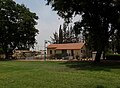
 פינה במושב
 -
 חממות
חממות -
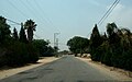 רחוב במושב
 -
 גן ילדים
 -
 במושב
במושב


קישורים חיצוניים
הערות שוליים
- ^ 1 2 אוכלוסייה בעיריות, במועצות המקומיות והאזוריות וביישובים בעלי 2,000 תושבים לפחות - לפי טבלה חודשית של למ"ס עבור סוף דצמבר 2024 (אומדן), בכל יתר היישובים - לפי טבלה שנתית של למ"ס עבור סוף 2023.
- ^ הנתונים לפי טבלת מדד חברתי כלכלי של למ"ס נכון לשנת 2021