קובץ:1947-UN-Partition-Plan-1949-Armistice-Comparison.svg

מתוך ויקיפדיה, האנציקלופדיה החופשית
קפיצה לניווט קפיצה לחיפוש

לקובץ המקורי (קובץ SVG, הגודל המקורי: 367 × 1,029 פיקסלים, גודל הקובץ: 48 ק"ב)

ויקישיתוף זהו קובץ שמקורו במיזם ויקישיתוף. תיאורו בדף תיאור הקובץ המקורי (בעברית) מוצג למטה.

תקציר

תיאור
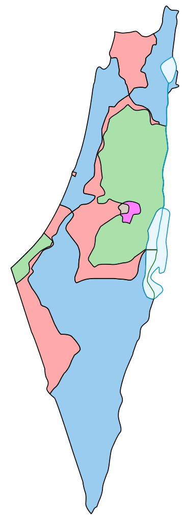
English: Comparison between the boundaries in the November 29th 1947 United Nations General Assembly partition plan (Resolution 181) for the British Mandate Territory of Palestine and the eventual armistice boundaries of 1949-1950. The meaning of the map colors is as follows (a legend caption is available in template form here):
  • Blue = area assigned to a Jewish state in the original UN partition plan, and within the 1949 Israel armistice lines.
  • Green = area assigned to an Arab state in the original UN partition plan, and controlled by Egypt or Jordan from 1949-1967.
  • Light red = area assigned to an Arab state in the original UN partition plan, but within the 1949 Israel armistice lines.
  • Magenta = area assigned to the "Corpus Separatum" of Jerusalem/Bethlehem (neither Jewish nor Arab) by the plan, but controlled by Jordan from 1949-1967.
  • Greyish = area assigned to the "Corpus Separatum" of Jerusalem/Bethlehem (neither Jewish nor Arab) by the plan, but within the 1949 Israel armistice lines.

Some limitations of the map:

  1. The small demilitarized zones are not shown. Arabs interpreted these areas as neutral intermediate buffers (like the Neutral Zones between Iraq and Saudi Arabia, or between Kuwait and Saudi Arabia), while Israel interpreted them as full sovereign Israeli national territory under a demilitarization treaty obligation. The conflict between these two interpretations produced frictions which effectively eliminated the special status of most of the zones within a few years.
  2. A small area at the northeastern corner of the green area on the map -- which would have belonged to the Jewish state according to the original UN partition plan, but which was controlled by Jordan from 1949-1967 -- is not distinguished on the map.
  3. The Latrun Salient no-man's-land is not shown separately, and the line between green and light red in that area is somewhat fudged. The boundary complications in the Jerusalem area (the Jerusalem no-man's-land, Mount Scopus theoretical enclave, etc.) are too small to show up on a map of this level of detail.
  4. The map cannot show that the pre-1948 boundaries of the British Palestine Mandate included a ten-meter-wide strip along the northeastern shore of the Sea of Galilee (making it a fully-enclosed British mandate lake), a strip which was overrun by Syria in the fighting of 1948-1949.
תאריך יצירה
מקור This is a partial SVG conversion (omitting text) of the original PostScript vector source of raster Image:1947-UN-Partition-Plan-1949-Armistice-Comparison.png by User:AnonMoos. Apparently, http://unispal.un.org/UNISPAL.NSF/0/651C804E6815FB28852575DF004B7C4C, ANNEX II, is the ultimate (UN) source.
יוצר AnonMoos
גרסאות אחרות

Derivative works of this file:  Palaestina 1947.svg[עריכה]

רישיון

Public domain היצירה הזאת שוחררה לנחלת הכלל על־ידי היוצר שלה, AnonMoos. זה תקף בכל העולם.

יש מדינות שבהן הדבר אינו אפשרי על פי חוק, אם כך:
AnonMoos מעניק לכל אחד את הזכות להשתמש ביצירה הזאת לכל מטרה, ללא שום תנאי, אלא אם כן תנאים כאלה נדרשים לפי החוק.

כיתובים

נא להוסיף משפט שמסביר מה הקובץ מייצג

פריטים שמוצגים בקובץ הזה

מוצג

image/svg+xml

checksum אנגלית

61992d864cc3b969cdb625ec1db7016f01f9017f

49,350 בית

1,029 פיקסל

367 פיקסל

היסטוריית הקובץ

ניתן ללחוץ על תאריך/שעה כדי לראות את הקובץ כפי שנראה באותו זמן.

תאריך/שעהתמונה ממוזערתממדיםמשתמשהערה
נוכחית19:38, 8 בנובמבר 2013תמונה ממוזערת לגרסה מ־19:38, 8 בנובמבר 2013‪1,029 × 367‬ (48 ק"ב)wikimediacommons>Ori~Reverted to version as of 16:16, 7 May 2013

הדפים הבאים משתמשים בקובץ הזה: