גדיש
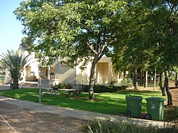
גָּדִישׁ הוא מושב בגוש יישובי אומן, שמהווה את אחד משלושת גושי היישובים בחבל תענך שבדרום עמק יזרעאל המשתייך למועצה אזורית הגלבוע.
 | |
| מדינה | |
| מחוז | הצפון |
| מועצה אזורית | הגלבוע |
| גובה ממוצע[1] | 66 מטר |
| תאריך ייסוד | 1956 |
| תנועה מיישבת | תנועת המושבים |
| סוג יישוב | מושב |
| נתוני אוכלוסייה לפי הלמ"ס לסוף 2023[1] | |
| - אוכלוסייה | 347 תושבים |
| - מתוכם, תושבי ישראל | 338 תושבי ישראל |
<mapframe align="left" height="350" latitude="32.574366413977" longitude="35.37" text="<center>מפת היישובים של מועצה אזורית הגלבוע<br />באדום - גדיש<br />בירוק - מיקום בניין המועצה</center>" width="440" zoom="11">[{"properties":{"title":"geomask1","fill-opacity":0.5},"type":"ExternalData","service":"geomask","ids":"Q2915451"},{"features":[{"type":"Feature","geometry":{"coordinates":[35.4038295523919,32.634494352941],"type":"Point"},"properties":{"fill-opacity":0.5,"title":"טמרה (יזרעאל)","marker-color":"#0000FF"}},{"type":"Feature","geometry":{"coordinates":[35.3913189370767,32.6141347433161],"type":"Point"},"properties":{"fill-opacity":0.5,"title":"נאעורה","marker-color":"#0000FF"}},{"type":"Feature","geometry":{"coordinates":[35.4448829237101,32.6040344228854],"type":"Point"},"properties":{"fill-opacity":0.5,"title":"טייבה (בעמק)","marker-color":"#0000FF"}},{"type":"Feature","geometry":{"coordinates":[35.4144917288495,32.5911943329735],"type":"Point"},"properties":{"fill-opacity":0.5,"title":"רמת צבי","marker-color":"#0000FF"}},{"type":"Feature","geometry":{"coordinates":[35.4406818868611,32.5863686310873],"type":"Point"},"properties":{"fill-opacity":0.5,"title":"מולדת","marker-color":"#0000FF"}},{"type":"Feature","geometry":{"coordinates":[35.2452282647887,32.5690907416102],"type":"Point"},"properties":{"fill-opacity":0.5,"title":"ניר יפה","marker-color":"#0000FF"}},{"type":"Feature","geometry":{"coordinates":[35.3598078526278,32.5671978179608],"type":"Point"},"properties":{"fill-opacity":0.5,"title":"כפר יחזקאל","marker-color":"#0000FF"}},{"type":"Feature","geometry":{"coordinates":[35.3720521862433,32.5662803427296],"type":"Point"},"properties":{"fill-opacity":0.5,"title":"גבע","marker-color":"#0000FF"}},{"type":"Feature","geometry":{"coordinates":[35.2373461228539,32.5638630146604],"type":"Point"},"properties":{"fill-opacity":0.5,"title":"מלאה","marker-color":"#0000FF"}},{"type":"Feature","geometry":{"coordinates":[35.3912142255067,32.5636382899436],"type":"Point"},"properties":{"fill-opacity":0.5,"title":"עין חרוד איחוד","marker-color":"#0000FF"}},{"type":"Feature","geometry":{"coordinates":[35.2424571037704,32.5633205354398],"type":"Point"},"properties":{"fill-opacity":0.5,"title":"מרכז אומן","marker-color":"#0000FF"}},{"type":"Feature","geometry":{"coordinates":[35.3210399852088,32.5621901087044],"type":"Point"},"properties":{"fill-opacity":0.5,"title":"יזרעאל","marker-color":"#0000FF"}},{"type":"Feature","geometry":{"coordinates":[35.2447977526787,32.5589013237482],"type":"Point"},"properties":{"fill-opacity":0.5,"title":"גדיש","marker-color":"#FF0000"}},{"type":"Feature","geometry":{"coordinates":[35.3915228249051,32.5584078014186],"type":"Point"},"properties":{"fill-opacity":0.5,"title":"עין חרוד מאוחד","marker-color":"#0000FF"}},{"type":"Feature","geometry":{"coordinates":[35.3074052246211,32.5576933714971],"type":"Point"},"properties":{"fill-opacity":0.5,"title":"אביטל","marker-color":"#0000FF"}},{"type":"Feature","geometry":{"coordinates":[35.399610355648,32.5562313419114],"type":"Point"},"properties":{"fill-opacity":0.5,"title":"תל יוסף","marker-color":"#0000FF"}},{"type":"Feature","geometry":{"coordinates":[35.2640662135822,32.5528520594282],"type":"Point"},"properties":{"fill-opacity":0.5,"title":"דבורה","marker-color":"#0000FF"}},{"type":"Feature","geometry":{"coordinates":[35.3080374558642,32.5519217702802],"type":"Point"},"properties":{"fill-opacity":0.5,"title":"מרכז יעל","marker-color":"#0000FF"}},{"type":"Feature","geometry":{"coordinates":[35.4387805077462,32.5514753658626],"type":"Point"},"properties":{"fill-opacity":0.5,"title":"בית השיטה","marker-color":"#0000FF"}},{"type":"Feature","geometry":{"coordinates":[35.394968,32.550219],"type":"Point"},"properties":{"fill-opacity":0.5,"title":"בניין מועצה אזורית הגלבוע","marker-color":"#00FF00"}},{"type":"Feature","geometry":{"coordinates":[35.3586053632972,32.5489843491178],"type":"Point"},"properties":{"fill-opacity":0.5,"title":"גדעונה","marker-color":"#0000FF"}},{"type":"Feature","geometry":{"coordinates":[35.2719421290988,32.5489706272988],"type":"Point"},"properties":{"fill-opacity":0.5,"title":"אדירים","marker-color":"#0000FF"}},{"type":"Feature","geometry":{"coordinates":[35.2643823928825,32.5479825534264],"type":"Point"},"properties":{"fill-opacity":0.5,"title":"מרכז חבר","marker-color":"#0000FF"}},{"type":"Feature","geometry":{"coordinates":[35.3007910964203,32.5458859291354],"type":"Point"},"properties":{"fill-opacity":0.5,"title":"מיטב","marker-color":"#0000FF"}},{"type":"Feature","geometry":{"coordinates":[35.3107984310534,32.5457876836878],"type":"Point"},"properties":{"fill-opacity":0.5,"title":"פרזון","marker-color":"#0000FF"}},{"type":"Feature","geometry":{"coordinates":[35.264911275338,32.5428424206693],"type":"Point"},"properties":{"fill-opacity":0.5,"title":"ברק","marker-color":"#0000FF"}},{"type":"Feature","geometry":{"coordinates":[35.3597623627418,32.5407771615309],"type":"Point"},"properties":{"fill-opacity":0.5,"title":"נורית","marker-color":"#0000FF"}},{"type":"Feature","geometry":{"coordinates":[35.3379258269829,32.5319652701614],"type":"Point"},"properties":{"fill-opacity":0.5,"title":"גן נר","marker-color":"#0000FF"}},{"type":"Feature","geometry":{"coordinates":[35.2596850431375,32.5268841198289],"type":"Point"},"properties":{"fill-opacity":0.5,"title":"רם און","marker-color":"#0000FF"}},{"type":"Feature","geometry":{"coordinates":[35.3233305500352,32.5226920537717],"type":"Point"},"properties":{"fill-opacity":0.5,"title":"סנדלה","marker-color":"#0000FF"}},{"type":"Feature","geometry":{"coordinates":[35.3076827858786,32.5210827556756],"type":"Point"},"properties":{"fill-opacity":0.5,"title":"מגן שאול","marker-color":"#0000FF"}},{"type":"Feature","geometry":{"coordinates":[35.4257107174255,32.5185858528049],"type":"Point"},"properties":{"fill-opacity":0.5,"title":"חפציבה","marker-color":"#0000FF"}},{"type":"Feature","geometry":{"coordinates":[35.4314542733503,32.5171328324454],"type":"Point"},"properties":{"fill-opacity":0.5,"title":"בית אלפא","marker-color":"#0000FF"}},{"type":"Feature","geometry":{"coordinates":[35.2961810756462,32.5142384750122],"type":"Point"},"properties":{"fill-opacity":0.5,"title":"מוקייבלה","marker-color":"#0000FF"}}],"type":"FeatureCollection"}]</mapframe>
| |
| מדד חברתי-כלכלי - אשכול לשנת 2021[2] |
5 מתוך 10 |
היישוב הוקם על ידי עולים ממרוקו בשנת 1956 במטרה ליישב את חבל תענך.
שמו של היישוב סמלי, מעולם החקלאות, הגדיש הוא ערימת תבואה.
ב-12 בינואר 2003 חדרו למושב מחבלים מארגון הג'יהאד האסלאמי הפלסטיני מקבטיה ורצחו את סייר הביטחון של המועצה האזורית גלבוע, אלי ביטון. לאחר מרדף של כוחות הביטחון וקרב יריות שבו נפצעו שלשה קציני משמר הגבול, המחבלים נורו למוות.[3]
קישורים חיצוניים
- גדיש באתר הרשות לפיתוח הגליל
- גדיש, במרכז המידע לנגב ולגליל של תנועת אור
הערות שוליים
- ^ 1 2 אוכלוסייה בעיריות, במועצות המקומיות והאזוריות וביישובים בעלי 2,000 תושבים לפחות - לפי טבלה חודשית של למ"ס עבור סוף דצמבר 2024 (אומדן), בכל יתר היישובים - לפי טבלה שנתית של למ"ס עבור סוף 2023.
- ^ הנתונים לפי טבלת מדד חברתי כלכלי של למ"ס נכון לשנת 2021
- ^ שני הרוגים ישראלים במושב גדיש וליד ניצנה, באתר ynet, 13 בינואר 2003


