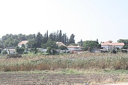
פתחיה
 | |
| מדינה | |
| מחוז | המרכז |
| מועצה אזורית | גזר |
| גובה ממוצע[1] | 102 מטר |
| תאריך ייסוד | 1951 |
| תנועה מיישבת | העובד הציוני |
| סוג יישוב | מושב |
| נתוני אוכלוסייה לפי הלמ"ס לסוף 2023[1] | |
| - אוכלוסייה | 915 תושבים |
| - מתוכם, תושבי ישראל | 866 תושבי ישראל |
<mapframe align="left" height="300" latitude="31.867" longitude="34.9" text="<center>מפת היישובים של מועצה אזורית גזר<br />באדום - פתחיה<br />בירוק - מיקום בניין המועצה</center>" width="320" zoom="11">[{"properties":{"title":"geomask1","fill-opacity":0.5},"type":"ExternalData","service":"geomask","ids":"Q2693373"},{"features":[{"type":"Feature","geometry":{"coordinates":[34.8242080812509,31.9232161851947],"type":"Point"},"properties":{"fill-opacity":0.5,"title":"נצר סרני","marker-color":"#0000FF"}},{"type":"Feature","geometry":{"coordinates":[34.8479243834389,31.9151687293919],"type":"Point"},"properties":{"fill-opacity":0.5,"title":"ישרש","marker-color":"#0000FF"}},{"type":"Feature","geometry":{"coordinates":[34.873013519721,31.906398951016],"type":"Point"},"properties":{"fill-opacity":0.5,"title":"מצליח","marker-color":"#0000FF"}},{"type":"Feature","geometry":{"coordinates":[34.9007323406061,31.9001555982756],"type":"Point"},"properties":{"fill-opacity":0.5,"title":"יד רמב\"ם","marker-color":"#0000FF"}},{"type":"Feature","geometry":{"coordinates":[34.9094317016849,31.8904364562706],"type":"Point"},"properties":{"fill-opacity":0.5,"title":"עזריה","marker-color":"#0000FF"}},{"type":"Feature","geometry":{"coordinates":[34.8446379690568,31.8902692904435],"type":"Point"},"properties":{"fill-opacity":0.5,"title":"סתריה","marker-color":"#0000FF"}},{"type":"Feature","geometry":{"coordinates":[34.9323693888267,31.8902171611371],"type":"Point"},"properties":{"fill-opacity":0.5,"title":"כפר שמואל","marker-color":"#0000FF"}},{"type":"Feature","geometry":{"coordinates":[34.9185271869824,31.8887438128885],"type":"Point"},"properties":{"fill-opacity":0.5,"title":"בית חשמונאי","marker-color":"#0000FF"}},{"type":"Feature","geometry":{"coordinates":[34.917376,31.88859],"type":"Point"},"properties":{"fill-opacity":0.5,"title":"בניין מועצה אזורית גזר","marker-color":"#00FF00"}},{"type":"Feature","geometry":{"coordinates":[34.8577699935432,31.8835421915888],"type":"Point"},"properties":{"fill-opacity":0.5,"title":"נען","marker-color":"#0000FF"}},{"type":"Feature","geometry":{"coordinates":[34.8537728571882,31.8784810139589],"type":"Point"},"properties":{"fill-opacity":0.5,"title":"גני הדר","marker-color":"#0000FF"}},{"type":"Feature","geometry":{"coordinates":[34.9198324556251,31.8767524984595],"type":"Point"},"properties":{"fill-opacity":0.5,"title":"גזר","marker-color":"#0000FF"}},{"type":"Feature","geometry":{"coordinates":[34.8561152486132,31.8738881732238],"type":"Point"},"properties":{"fill-opacity":0.5,"title":"רמות מאיר","marker-color":"#0000FF"}},{"type":"Feature","geometry":{"coordinates":[34.8256834241047,31.8728090183921],"type":"Point"},"properties":{"fill-opacity":0.5,"title":"כפר ביל\"ו","marker-color":"#0000FF"}},{"type":"Feature","geometry":{"coordinates":[34.94552891058,31.87139656481],"type":"Point"},"properties":{"fill-opacity":0.5,"title":"משמר איילון","marker-color":"#0000FF"}},{"type":"Feature","geometry":{"coordinates":[34.9052672718464,31.8707669658166],"type":"Point"},"properties":{"fill-opacity":0.5,"title":"בית עוזיאל","marker-color":"#0000FF"}},{"type":"Feature","geometry":{"coordinates":[34.9837867144102,31.8705670083626],"type":"Point"},"properties":{"fill-opacity":0.5,"title":"שעלבים","marker-color":"#0000FF"}},{"type":"Feature","geometry":{"coordinates":[34.9887579824432,31.8686817158137],"type":"Point"},"properties":{"fill-opacity":0.5,"title":"נוף איילון","marker-color":"#0000FF"}},{"type":"Feature","geometry":{"coordinates":[34.885728475457,31.8673826660865],"type":"Point"},"properties":{"fill-opacity":0.5,"title":"פתחיה","marker-color":"#FF0000"}},{"type":"Feature","geometry":{"coordinates":[34.8603826801424,31.8630779363656],"type":"Point"},"properties":{"fill-opacity":0.5,"title":"יציץ","marker-color":"#0000FF"}},{"type":"Feature","geometry":{"coordinates":[34.9471401515332,31.8620208466447],"type":"Point"},"properties":{"fill-opacity":0.5,"title":"כפר בן נון","marker-color":"#0000FF"}},{"type":"Feature","geometry":{"coordinates":[34.8384229961641,31.8581466847395],"type":"Point"},"properties":{"fill-opacity":0.5,"title":"גני יוחנן","marker-color":"#0000FF"}},{"type":"Feature","geometry":{"coordinates":[34.8826962237403,31.8580862235866],"type":"Point"},"properties":{"fill-opacity":0.5,"title":"פדיה","marker-color":"#0000FF"}},{"type":"Feature","geometry":{"coordinates":[34.9203442888574,31.847714843943],"type":"Point"},"properties":{"fill-opacity":0.5,"title":"כרמי יוסף","marker-color":"#0000FF"}},{"type":"Feature","geometry":{"coordinates":[34.8825776208401,31.8313918381495],"type":"Point"},"properties":{"fill-opacity":0.5,"title":"חולדה","marker-color":"#0000FF"}},{"type":"Feature","geometry":{"coordinates":[34.9006688134012,31.8228689998246],"type":"Point"},"properties":{"fill-opacity":0.5,"title":"משמר דוד","marker-color":"#0000FF"}}],"type":"FeatureCollection"}]</mapframe>
| |
| מדד חברתי-כלכלי - אשכול לשנת 2021[2] |
7 מתוך 10 |
פְּתַחְיָה הוא מושב באזור השפלה ליד המועצה המקומית מזכרת בתיה השייך למועצה אזורית גזר.
היישוב הוקם בשנת 1951 ואדמותיו נרכשו על ידי קרן קיימת לישראל. ליישוב הגיעו עולים מתוניסיה ובשלב מאוחר יותר הצטרפו ליישוב עולים מאלג'יריה ומהודו. תחילה, נקרא היישוב "גזר 10".
הענף המרכזי במושב הוא הכרם. חלק מהתושבים עוסקים בעבודות שונות מחוץ ליישוב.[3]
קישורים חיצוניים
- פתחיה, באתר המועצה האזורית גזר
- א. פלג, מריבות מסכנות קיומה של פתחיה, מעריב, 4 באוקטובר 1963
הערות שוליים
- ^ 1 2 אוכלוסייה בעיריות, במועצות המקומיות והאזוריות וביישובים בעלי 2,000 תושבים לפחות - לפי טבלה חודשית של למ"ס עבור סוף דצמבר 2024 (אומדן), בכל יתר היישובים - לפי טבלה שנתית של למ"ס עבור סוף 2023.
- ^ הנתונים לפי טבלת מדד חברתי כלכלי של למ"ס נכון לשנת 2021
- ^ פתחיה, באתר מועצה אזורית גזר
| ||||||||||||


