דור (מושב)
קפיצה לניווט
קפיצה לחיפוש
 | |
| מדינה | |
| מחוז | חיפה |
| מועצה אזורית | חוף הכרמל |
| גובה ממוצע[1] | 4 מטר |
| תאריך ייסוד | 1949 |
| תנועה מיישבת | תנועת המושבים |
| סוג יישוב | מושב |
| נתוני אוכלוסייה לפי הלמ"ס לסוף 2023[1] | |
| - אוכלוסייה | 463 תושבים |
| - מתוכם, תושבי ישראל | 434 תושבי ישראל |
(למפת הכרמל רגילה)  דור
<mapframe align="center" height="550" latitude="32.629017086307" longitude="34.949301299699" text="<div style="text-align:center;">מפת היישובים של מועצה אזורית חוף הכרמל<br />באדום - דור<br />בירוק - מיקום בניין המועצה</div>" width="250" zoom="11">[{"properties":{"title":"geomask1","marker-color":"#0000FF"},"type":"ExternalData","service":"geomask","ids":"Q1915911"},{"features":[{"type":"Feature","geometry":{"coordinates":[34.958978867737,32.7659714932353],"type":"Point"},"properties":{"title":"כפר גלים","marker-color":"#0000FF"}},{"type":"Feature","geometry":{"coordinates":[34.956882355751,32.7522615341683],"type":"Point"},"properties":{"title":"החותרים","marker-color":"#0000FF"}},{"type":"Feature","geometry":{"coordinates":[35.0060142688368,32.7311590956266],"type":"Point"},"properties":{"title":"בית אורן","marker-color":"#0000FF"}},{"type":"Feature","geometry":{"coordinates":[34.958757997368,32.7298128568467],"type":"Point"},"properties":{"title":"מגדים","marker-color":"#0000FF"}},{"type":"Feature","geometry":{"coordinates":[34.9697724434238,32.7197349056496],"type":"Point"},"properties":{"title":"בית צבי","marker-color":"#0000FF"}},{"type":"Feature","geometry":{"coordinates":[34.9831546561293,32.7000118984182],"type":"Point"},"properties":{"title":"עין הוד","marker-color":"#0000FF"}},{"type":"Feature","geometry":{"coordinates":[34.9907276798561,32.6994840291754],"type":"Point"},"properties":{"title":"ניר עציון","marker-color":"#0000FF"}},{"type":"Feature","geometry":{"coordinates":[34.9997038608108,32.6915639866143],"type":"Point"},"properties":{"title":"עין חוד","marker-color":"#0000FF"}},{"type":"Feature","geometry":{"coordinates":[34.9426560370331,32.6910068637286],"type":"Point"},"properties":{"title":"עתלית","marker-color":"#0000FF"}},{"type":"Feature","geometry":{"coordinates":[34.9306417391041,32.6794392966622],"type":"Point"},"properties":{"title":"נווה ים","marker-color":"#0000FF"}},{"type":"Feature","geometry":{"coordinates":[34.9532518583476,32.6770520635679],"type":"Point"},"properties":{"title":"עין כרמל","marker-color":"#0000FF"}},{"type":"Feature","geometry":{"coordinates":[34.957826,32.676298],"type":"Point"},"properties":{"title":"בניין מועצה אזורית חוף הכרמל","marker-color":"#00FF00"}},{"type":"Feature","geometry":{"coordinates":[34.954677775509,32.6627176955579],"type":"Point"},"properties":{"title":"גבע כרמל","marker-color":"#0000FF"}},{"type":"Feature","geometry":{"coordinates":[34.9483221827055,32.64854795735],"type":"Point"},"properties":{"title":"צרופה","marker-color":"#0000FF"}},{"type":"Feature","geometry":{"coordinates":[34.9905348183576,32.646192493399],"type":"Point"},"properties":{"title":"כרם מהר\"ל","marker-color":"#0000FF"}},{"type":"Feature","geometry":{"coordinates":[34.9326889038371,32.6371534192029],"type":"Point"},"properties":{"title":"הבונים","marker-color":"#0000FF"}},{"type":"Feature","geometry":{"coordinates":[34.946352540404,32.6292471910528],"type":"Point"},"properties":{"title":"עין אילה","marker-color":"#0000FF"}},{"type":"Feature","geometry":{"coordinates":[34.9820675364369,32.6222822317771],"type":"Point"},"properties":{"title":"עופר","marker-color":"#0000FF"}},{"type":"Feature","geometry":{"coordinates":[34.9207208852807,32.6135920783485],"type":"Point"},"properties":{"title":"נחשולים","marker-color":"#0000FF"}},{"type":"Feature","geometry":{"coordinates":[34.9209524382724,32.6077314261302],"type":"Point"},"properties":{"title":"דור","marker-color":"#FF0000"}},{"type":"Feature","geometry":{"coordinates":[35.0035334235826,32.6004066379624],"type":"Point"},"properties":{"title":"בת שלמה","marker-color":"#0000FF"}},{"type":"Feature","geometry":{"coordinates":[34.9713857062127,32.5914239546702],"type":"Point"},"properties":{"title":"מאיר שפיה","marker-color":"#0000FF"}},{"type":"Feature","geometry":{"coordinates":[34.9405642420044,32.5681885791085],"type":"Point"},"properties":{"title":"מעיין צבי","marker-color":"#0000FF"}},{"type":"Feature","geometry":{"coordinates":[34.9160040429855,32.5561415666024],"type":"Point"},"properties":{"title":"מעגן מיכאל","marker-color":"#0000FF"}},{"type":"Feature","geometry":{"coordinates":[34.9258856342825,32.5283004512806],"type":"Point"},"properties":{"title":"בית חנניה","marker-color":"#0000FF"}},{"type":"Feature","geometry":{"coordinates":[34.9077525245928,32.5075190711756],"type":"Point"},"properties":{"title":"קיסריה","marker-color":"#0000FF"}},{"type":"Feature","geometry":{"coordinates":[34.892588330561,32.4920626793793],"type":"Point"},"properties":{"title":"שדות ים","marker-color":"#0000FF"}}],"type":"FeatureCollection"}]</mapframe>
| |
| מדד חברתי-כלכלי - אשכול לשנת 2021[2] |
8 מתוך 10 |

דּוֹר הוא מושב ליד זכרון יעקב השייך למועצה אזורית חוף הכרמל. הוקם בשנת 1949 על ידי קבוצת עולים יוצאי יוון, שלאחר מכן הצטרפו אליהם יוצאי עיראק.
היסטוריה
המושב הוקם על האדמות החקלאיות של הכפר הערבי טנטורה, שתושביו גורשו או ברחו לפי גישות שונות במחקר ההיסטורי במהלך מלחמת העצמאות ולא הורשו לחזור אליו לאחריה. שמו של המושב נובע משמה של העיר הקדומה דור ששכנה סמוך למקום. חוף דור, חוף הים הסמוך למושב, הוא אחד הנוחים לרחצה בישראל, עקב היותו בתוך מפרץ טבעי.
לאורך חוף דור ניתן למצוא שפע של צמחיית חופים, בעלי חיים עשירים וצמחיית חולות. החוף הצפוני של דור הוכרז כשמורת טבע.
גלריה
-
 המושב דור לכיוון דרום, אוגוסט 2020
 -
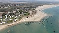 חוף הרחצה במבט אווירי, ספטמבר 2020


קישורים חיצוניים
הערות שוליים
- ^ 1 2 אוכלוסייה בעיריות, במועצות המקומיות והאזוריות וביישובים בעלי 2,000 תושבים לפחות - לפי טבלה חודשית של למ"ס עבור סוף דצמבר 2024 (אומדן), בכל יתר היישובים - לפי טבלה שנתית של למ"ס עבור סוף 2023.
- ^ הנתונים לפי טבלת מדד חברתי כלכלי של למ"ס נכון לשנת 2021
| ||||||||||||||||||